Let me start by saying that it is impossible to show here all of the many (hundreds!) of pictures that we took in Glacier National Park. The place is truly spectacular and probably our favorite National Park to date. The pictures that I do post really don’t do justice to the scenery in the park. You just need to come see it for yourself.
September 6, Friday, Glacier National Park, Montana
Debbie and I woke up early and found that there was a heavy fog rolling into the campground and was headed straight towards Glacier National Park, where we were also headed. As we drove into the park, the heavy fog followed us in and all the way to the Logan Pass Visitor Center in the middle of the park on the Going To The Sun Road. We started early so that we could get a jump on the people getting to the parking at Logan Pass. We’d heard that the parking lot had been filling up by 8:45-9:00 am. We pulled into the lot, completely fogged in with about 100 feet of visibility. The lot was almost full already and it was barely after 8:00! We managed to find one of the last available spots and walked over the visitor center so the Debbie could get her passport book stamped, only to find out that it didn’t open until 9:30. So, we decided to find a way to come back later in the day. Back at the truck, we continued west. Almost immediately after going through the pass, the sky opened up and was beautiful.
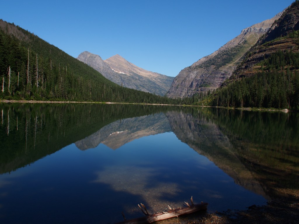
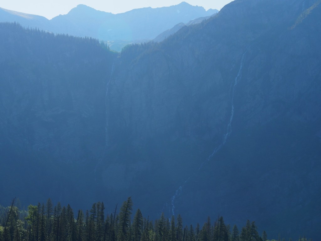
We drove down to the Avalanche Lake Trailhead and found that almost all of the parking spaces were again taken. It seemed that many people that were staying near the west side of the park were using the larger lot at that trailhead and taking the free park shuttle up to Logan Pass. I finally managed to find a spot that definitely was not made for a 3/4-ton crew cab truck, but managed to squeeze in. The trail to Avalanche Lake actually starts out along the Trail of the Cedars trail, a beautiful, fairly flat walk through a huge forest of very tall cedar trees. The temperature was perfect, at 45 degrees, for hiking. After covering about a quarter mile or so along the Trail of the Cedars, the Avalanche Lake Trail branches off, continuing though 150-foot tall cedar trees, but becoming a little more hilly. The hike to the lake covered nearly 2-1/2 miles, but rewarded us with a view of a pristine lake, surrounded by mountains, with two VERY tall waterfalls just past the lake. Unfortunately, we were so early that the sun hadn’t yet crested the mountains to fully illuminate the falls. There was a secondary trail that circled around one side of the lake. We made it the extra 1/2-to 3/4-mile to the other end in short order. The view from there, with the mountains reflecting in the calm lake were amazing. After taking a ton of pictures, we headed back to the truck to seek out another hike with some waterfalls. That hike totaled about six miles.
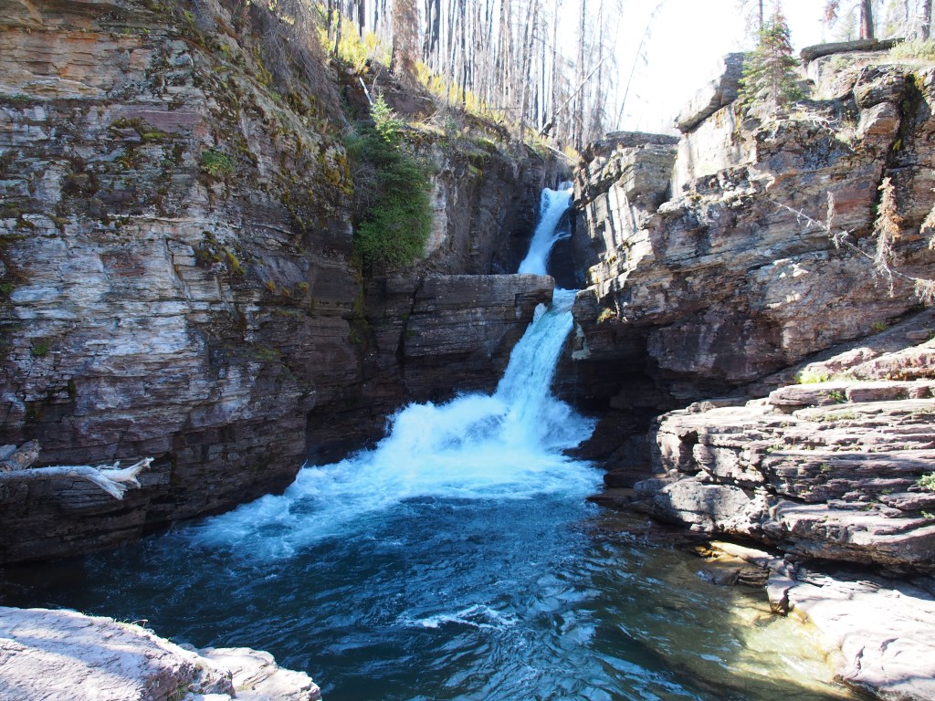
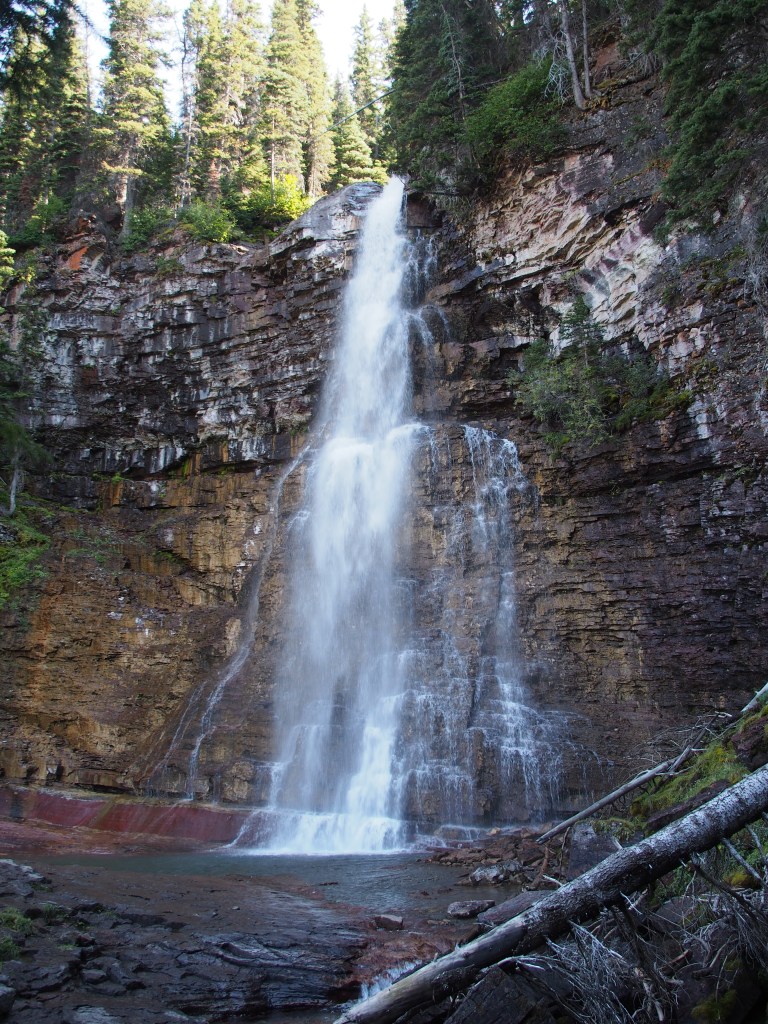
We drove back east and decided to try Logan Pass again. But again, the lot was full. Debbie ran in to get her stamp while I circled the lot looking for a nonexistent parking space. Picking her up after she was done, we headed back over to a group of that were supposed to hold quite a few waterfalls along their path. We started with Saint Mary Falls, which then led to Virginia Falls. Saint Mary Falls provided a really good view from a foot bridge just at the base of the multilevel falls. The was supposed to be a “less challenging hike”, but I would have rate it one notch higher. The trail to Virginia was rated as “challenging” and was every bit of that. It wasn’t that it was long, but it did have a good bit of elevation change. There were several spectacular unnamed falls all along the creek going to main 50-foot tall “bridal veil” type waterfall with a secondary waterfall and some cascades just below. The falling water and mist created quite a chilling effect to the air. This was an “out and back” hike, but as we neared our starting point, we branched off to a trail leading to Baring Falls. This is another cascading waterfall. Although we hiked to three named waterfalls this afternoon, there were about a half dozen really beautiful, and fairly large, waterfalls along this 5-1/2 mile hike. Total for the day, just over 11-1/2 miles.
September 7, Saturday, Glacier National Park
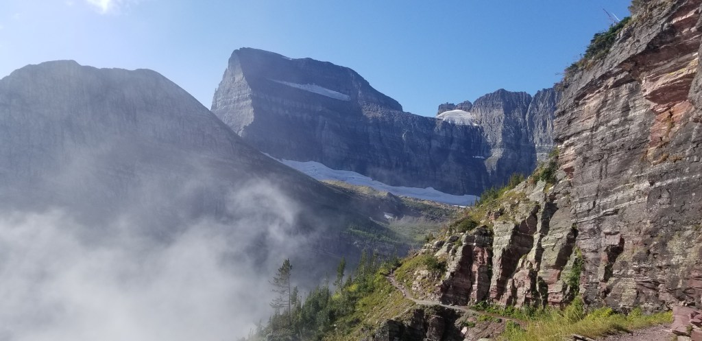
We saved our most challenging hike for our last day. We drove north into the Many Glaciers section of the park. There, we located the trailhead to the famous Grinnell Glacier Trail. This is listed as a “very challenging hike” in the parks trail guide. According to the signs at the start of the trail, it’s a 5.5 mile hike, EACH WAY, and includes a total elevation change of just over 3,600 feet. Much like the day before, it was really foggy and damp as we started our hike. Basically, we couldn’t see anything but the trail ahead of us for the first couple of miles. Luckily, as we got closer to the destination, the sky began to open up and provide some amazing views. Along the way, Debbie and I took an accidently detour that added not only extra length to an already log hike, but involved dropping down a couple of hundred feet, only to have to reaclimb that same trail. We also picked up a hiking buddy that was going it alone. Jenn DeBeers from Florida was a great hiking companion and we certainly enjoyed her company. She joined us for most of the hike up, and all of the hike back from the glaciers.
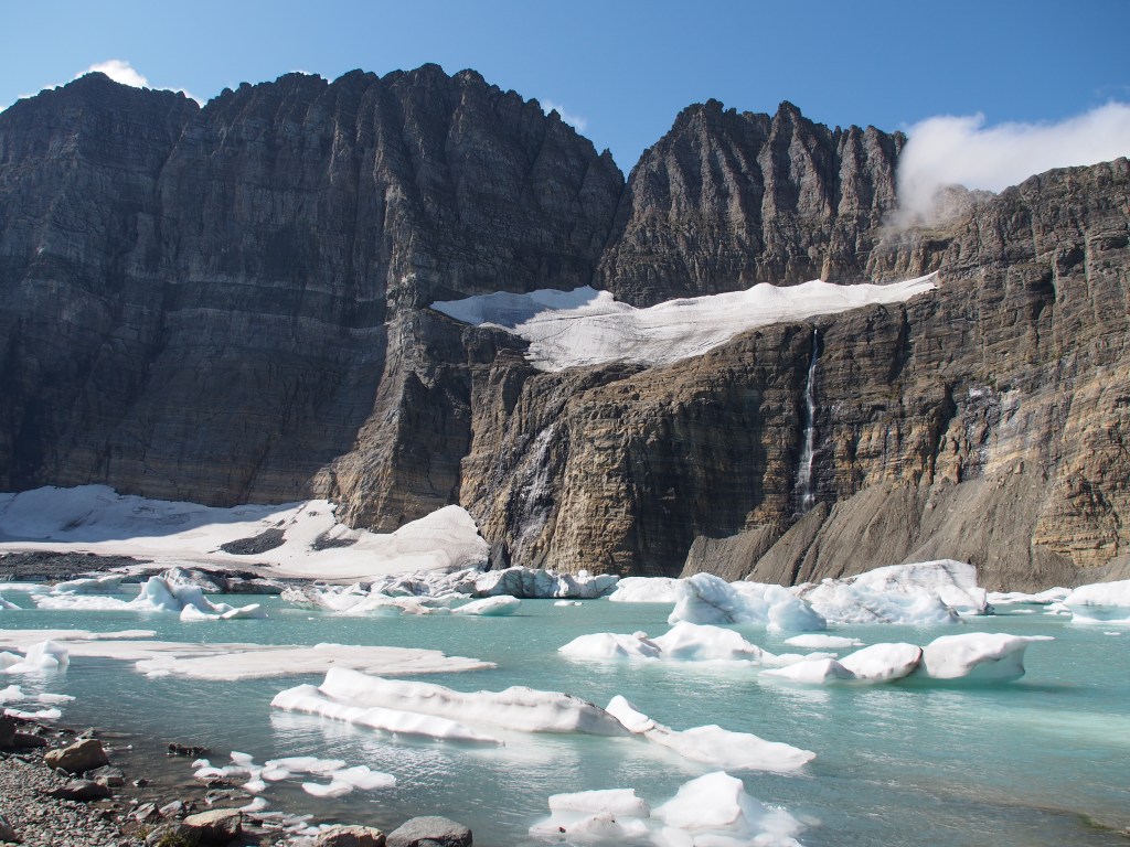
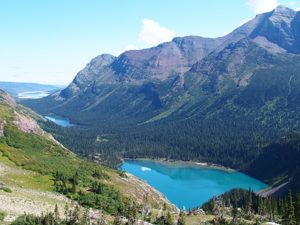
Once we broke the clouds and fog, the views were just like so many others in the park, AMAZING. Everywhere you look is like looking at a postcard. The real kicker of the hike is when you top one final crest and Upper Grinnell Lake, with its floating icebergs and Grinnell and Salamander Glaciers and several waterfalls just above, appear before you. It was so beautiful that we spend an hour just sitting and taking pictures. Over the course of the hike, we got pretty warm, even though the temperature was in the 60’s. But, sitting beside that lake with the wind blowing across it made it really pretty cold and we had to put back on the extra layers we’d pulled off just a few moments before. The hike back down provided many spectacular views. We could see all the way back down through the valley past Grinnell Lake and Lake Josephine to our starting point way off in the distance. By the time we returned to the trailhead, we had hike another 11.5 miles or so (due to our detour) and were quite exhausted.
September 8, Sunday, travel day
We spent the day on the road, driving from Saint Mary, MT on the east side of Glacier National Park to Gardiner, MT at the north entrance to Yellowstone National Park. We were unable to see a few of the areas of the park when we were here back in May due to both weather and road construction. We were also early enough back in Mary that a few of the park facilities had not yet been opened for the season. More about Yellowstone in my next installment.
