On Monday we packed up and moved from Benson, AZ to the small town of Ajo, AZ. Ajo is basically in the middle of nowhere, but is just a short drive north of Organ Pipe Cactus National Monument. The National Monument sits right on the border with Mexico in the Sonoran Desert.
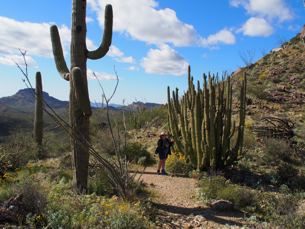
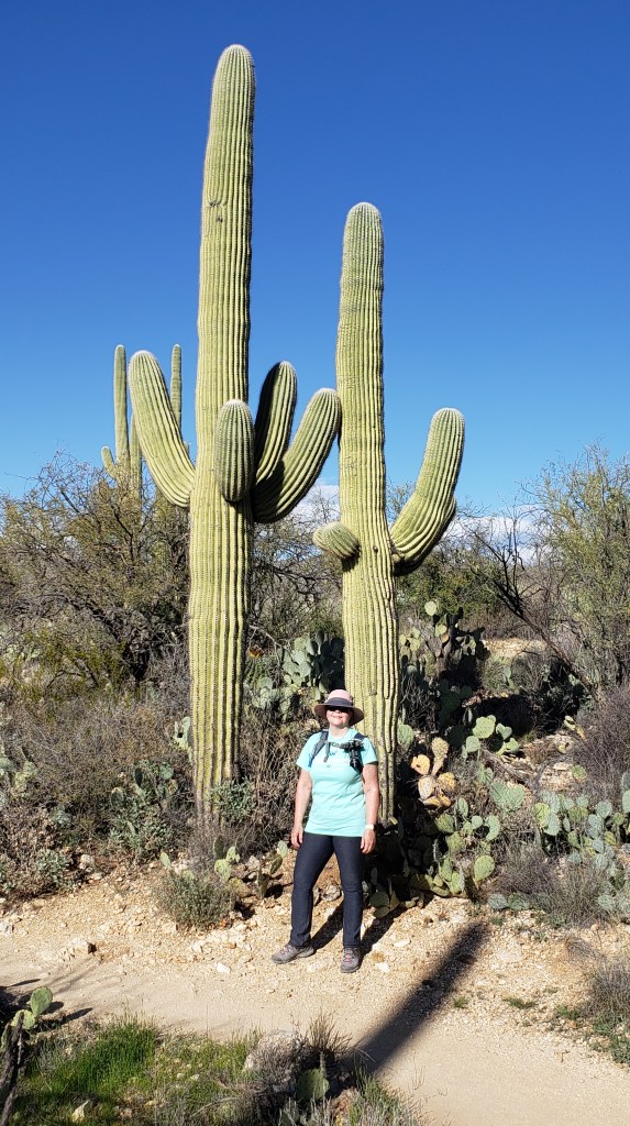
Debbie with an Organ Pipe Cactus
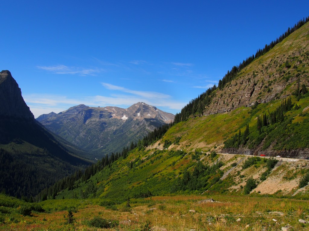
The visitor center had the obligatory video telling all about the desert and had a Cancellation Station so that Debbie could get her National Parks book stamped. We had a talk with a park ranger and decided to take the 21 mile Ajo Mountain Drive. The loop was graded gravel, with very rare stretches of old asphalt that was barely distinguishable from the dirt and gravel road. The drive included a lot of very impressive desert and mountain views. At about the midpoint, we found the parking area for a hike that was recommended by the park ranger.
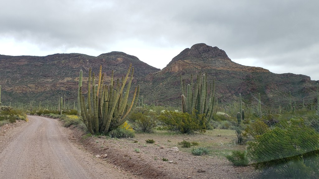
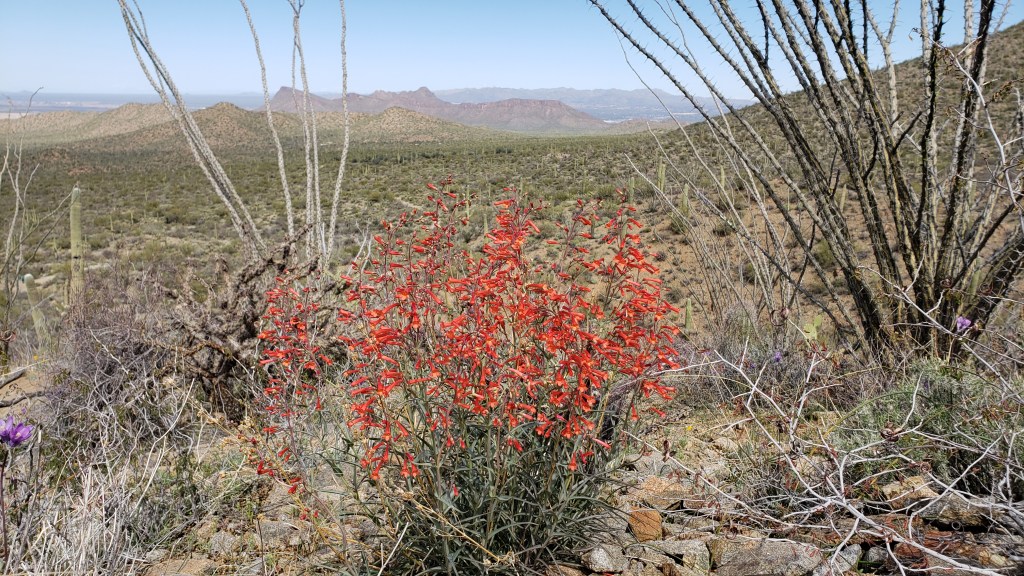
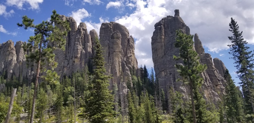
Organ Pipe Cactus along the Ajo Mountain Drive.More views along the drive.
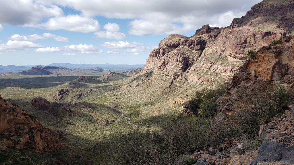
The trail was called the Estes Canyon / Bull Pasture Trail and was a total of 3.6 miles and gained about 950 feet in elevation. We started with the 1.5 mile Estes Canyon that began with a fairly flat 1.3 miles before ascending about 400 feet of mostly switchbacks over the last 0.2 miles. At that point, it joined the Bull Pasture Trail, which we took to the top of Bull Pasture. That out-and-back trail was 0.5 miles each way, but gained an additional nearly 500 feet of elevation. The views of the mountains and valleys below were amazing and you could easily see into Mexico from the top. Just before we reached the top, we met up with a group that had not only gone up to Bull Pasture, they went an additional 1500 feet in elevation to the top of Mount Ajo, the highest peak in the National Monument. After looking at it from our highest vantage point, we decided to leave that hike for another day.
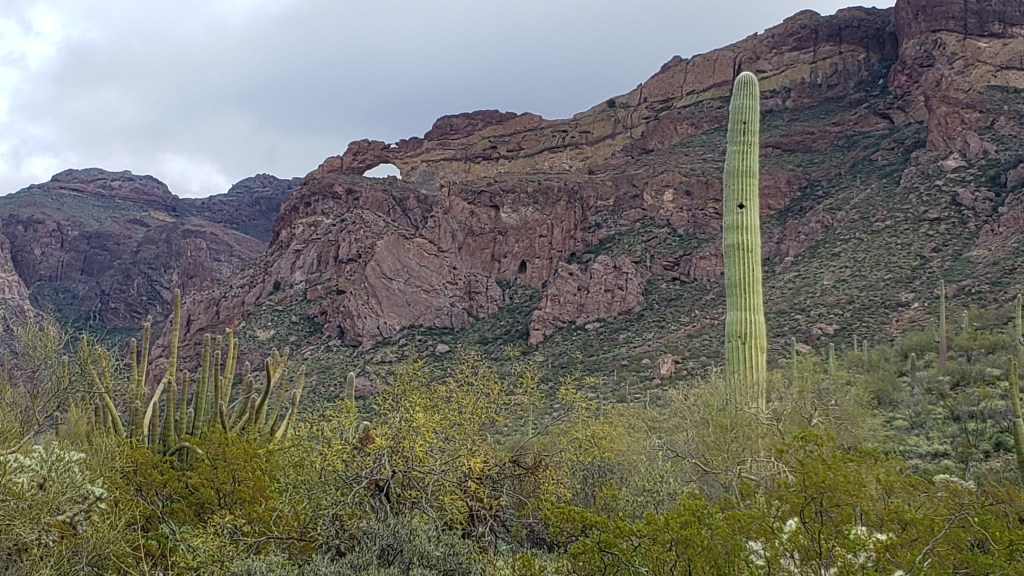
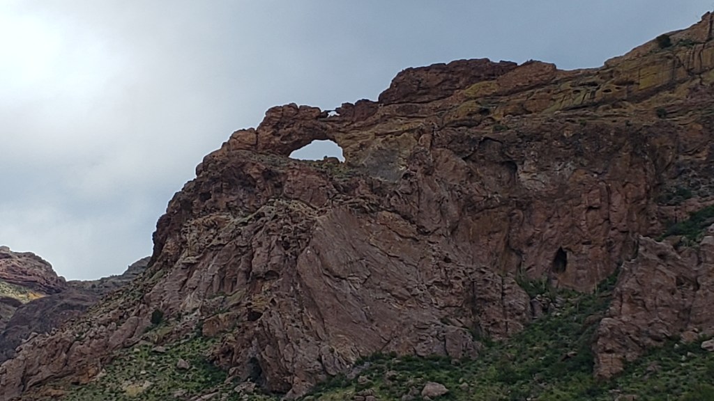
Arches, Saguaro, and Organ Pipe Cactus.Close up of the TWO arches (tiny one on top).
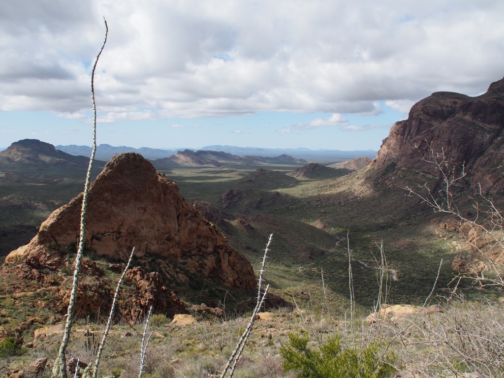
After soaking in the views from Bull Pasture (a name that I still don’t understand being that it’s at the top of a mountain), we began our decent back towards the valley below. Rather than retrace our path through Estes Canyon for the last 1.5 miles, we followed the shorter 1.0 mile descent along the remainder of the Bull Pasture Trail back to the truck. The views along that trail were completely different, but equally spectacular, as the Estes Canyon trail we had ascended earlier.
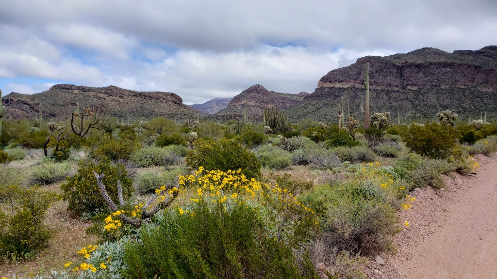
So many spectacular views along the trail.View from near the top of Bull Pasture Trail.
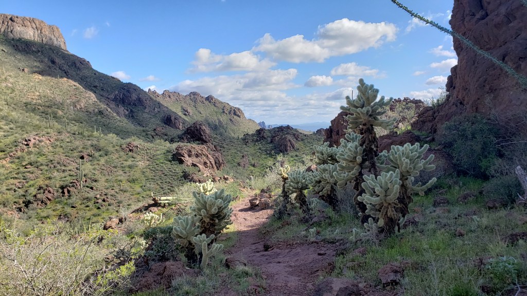
Once back in the truck, we continued on with the Ajo Mountain Drive. Along the way we saw many picturesque views of mountains, lots and lots of Organ Pipe and Saguaro cactus, Ocotillo bushes, and the strangely menacing Teddy Bear Cholla. A last stop back at the visitor center ended our journey through the park, after which we drove back to our home away from home. Tomorrow we’re off to Desert Hot Springs, CA and Joshua Tree National Park.
Benson, AZ; Kartchner Caverns State Park; Feb. 27 – Mar. 2
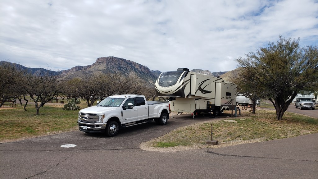
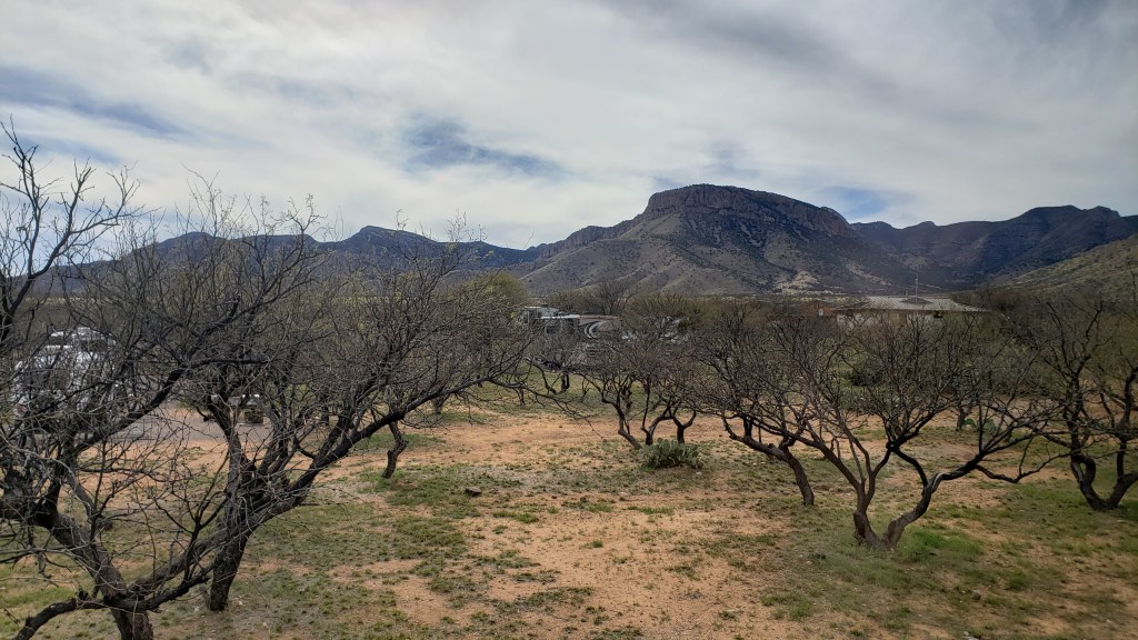
We had a very short drive on Thursday from Deming, NM to Benson, AZ on I-10, then south just a few miles to Kartchner Caverns State Park. This is a very nice campground with plenty of space between spots. Since we’d arrived so early, we decided to go for a hike behind the campground and visitor center. The Foothills Loop was three miles, beginning at the campground and running up to the base of the mountains and back down through a canyon. We opted to take an additional spur, 0.3 miles each way, UP the Mountain Viewpoint trail. Let’s just say that not having hiked since November left us a bit exhausted by the time we got back to camp, but the view of the valley and the Chiricahua Mountains made it worth the effort.
Our Campsite at Kartchner Caverns State ParkView out our window at Kartchner Caverns State ParkChiricahua Mountains with Cochise’s Stronghold in the center.
On Friday morning, we had reservations to take one of the cave tours here at the park. I highly recommend the hour and a half tour to anyone staying in the area just east of Tucson. The discoverers of the caverns, the property owners, and the State of Arizona did an excellent job of protecting the cave. They spent several years interviewing the operators of several of the other cave systems around the country in order to find out all of the things they’d change if they could. Then, Arizona incorporated those ideas into preserving this spectacular cave. Unfortunately, they make all visitors store their cell phones, cameras, etc. in lockers prior to entering the cave, so I don’t have any pictures to share.
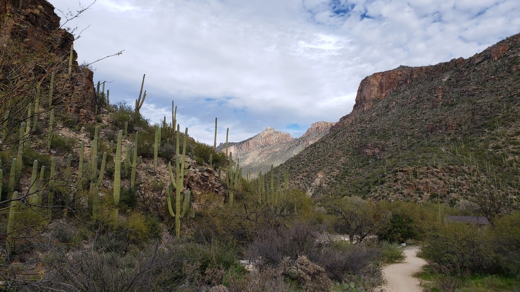
After our early cave tour, we drove over to the Sabino Canyon Recreation Area. This is a spectacular area among the mountains and canyons to the northeast of Tucson. There are many hiking trails for everyone from the novice “path walk” hiker to the very experienced backpacker. The area borders the Pusch Ridge Wilderness and many of the trail extend outside the recreation area and into the wilderness area. We opted to connect several shorter trails into an approximate 4.3 mile “moderate” hike.
View along the Sabino Canyon hike.Sabino Dam.
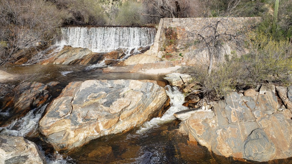
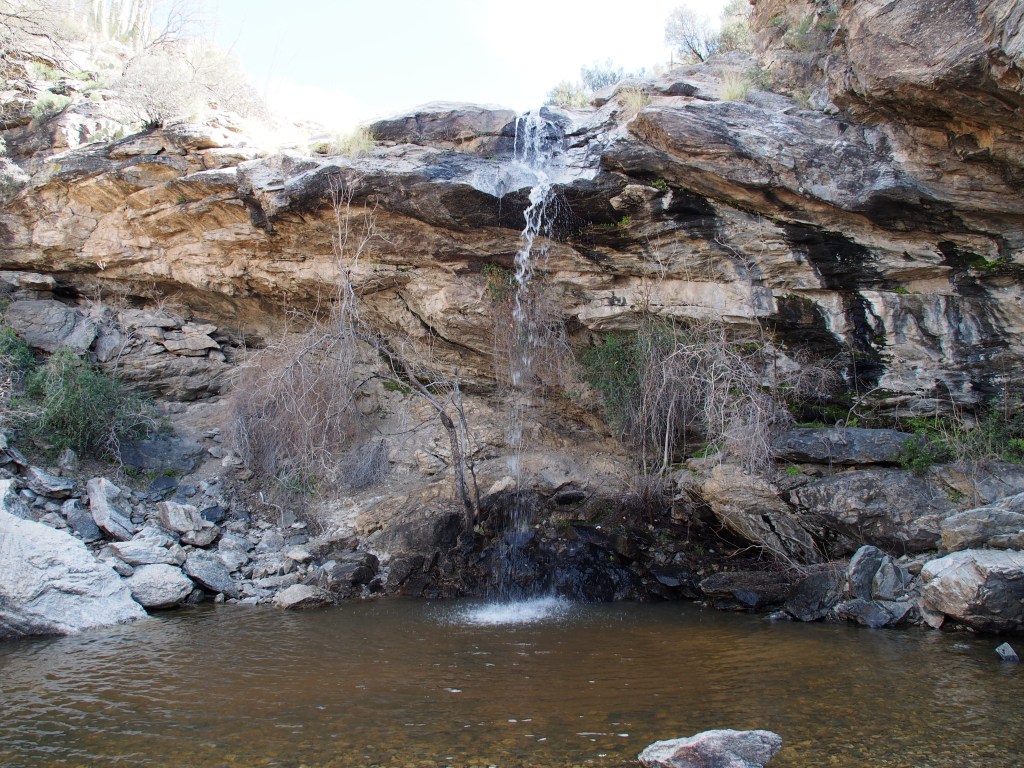
On Saturday, we headed over to the eastern section of the Saguaro National Park, also known as the Rincon Mountain District. After watching the video at the visitor center and letting Debbie get her Park Passbook stamped, we drove the Cactus Forest Loop, which was a one-way, paved road with several pull-offs with really amazing views. After that, we took a fairly strenuous hike of about six miles round trip, with about 1,000 feet of elevation gain, up to Bridal Wreath Falls. We were told how spectacular the falls were, but we found it a bit disappointing after such a hard hike. It was a pretty falls, but just not awe inspiring. Saturday was a beautiful day, with sunny skies and a high in the upper-70’s. But, as we got back to our campground, the wind picked up and it blew pretty hard all night long.
Bridal Wreath Falls.At the end of a long hike.
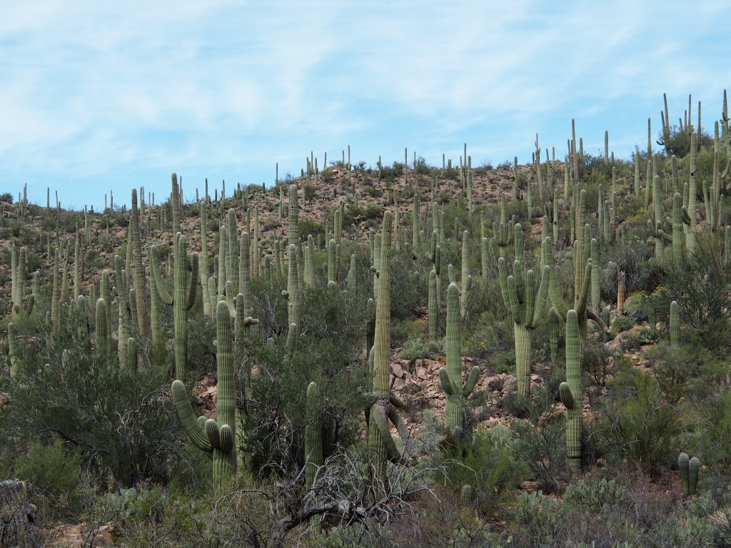
Sunday morning turned out to be mostly cloudy and the temperature never got above the low 60’s. We drove an hour or so over to the western district of Saguaro National Park; also known as the Tucson Mountain District. This smaller section of the national park is known for having a higher concentration of Saguaro cactus than the eastern district and we found that to be accurate. We started with the Red Hills Visitor Center’s movie, which was very interesting in how it related the desert and its life to the lives of the Native Americans in the area, and to all people visiting the park. They had a spectacular ending where the screen raised up and the curtains opened to reveal a huge window looking out onto a very densely packed “forest” of Saguaro cactus.
A Saguaro Cactus forest.
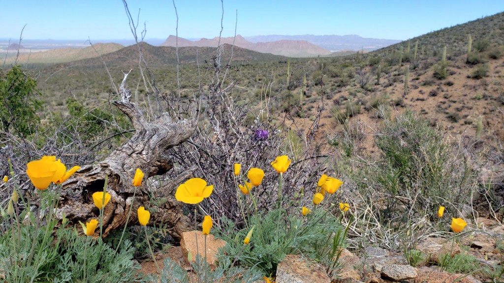
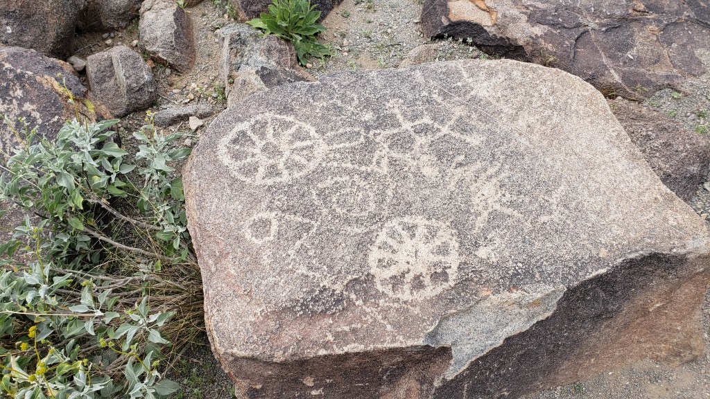
We followed that with a drive along an unpaved road that circled through a small portion of the park. At about the halfway point, we parked and took a hike of about 3.4 miles, round trip, with an elevation gain of approximately 750 feet. Most of the elevation gain took place in the last quarter mile or so. (Debbie just LOVES switchback trails.) The view from the top was very nice and we were able to view the valleys on both sides of the mountain. There were many more wildflowers in this park than in the eastern district portion of the park. There were all the colors you can think of, but yellow seemed to dominate. On our way out of the park, we stopped for a short walk up to see the Signal Hill Petroglyphs, which were carved there by the prehistoric Hohokam people. We finished off the day by returning to camp and grilling a nice ribeye for dinner. Tomorrow, we’re off to Ajo, AZ for a couple of days.
Can you see our truck at the base of the hill just over the top of the red bush?Petroglyphs carved by ancient Hohokam people.
Debbie and I have wanted to visit Death Valley National Park in California and know that winter is the best time to do so. We began making plans back around Thanksgiving 2019 to take our new 2020 Grand Design Solitude S-Class 2930RL-R fifth wheel and heading out west. Over the next few weeks, I hope to post about our month long experience getting there and back.
Planning To Dry Camp. We had made a couple of minor changes to our new trailer to make it possible to make stops along the way, without having hookups. Since the new trailer had a residential refrigerator, which would be running on an inverter, we knew the two standard, lead-acid batteries wouldn’t get the job done. So, we replaced those with a couple of lithium-ion batteries and a new lithium-compatible battery charger. The new batteries effectively raised our capacity by 2-1/2 times.
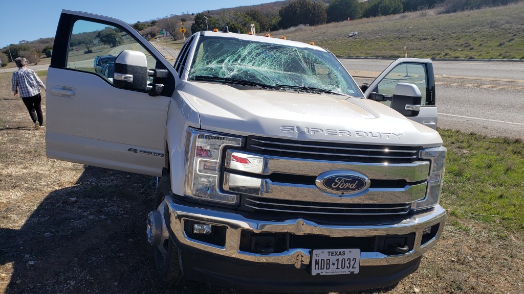
Uh-Oh, We Have a Problem. As we were getting close to time for this trip to begin, it turned into “the trip that almost wasn’t”. Just about three weeks before our scheduled departure, we were involved in an accident with our new 2019 F-350 dually. We were helping out some friends by carrying some of their stuff from Gordon to their new home near Fredericksburg, TX. While driving into Goldthwaite, TX, a woman in a Lexus managed to “not see” our huge crew cab dually truck and ran through a yield sign. We bumped sides like they do in NASCAR before both heading off the side of the road. The damage to our truck would have been minimal, but we decided to run over a road sign in the process of going off-road. The sign crashed into our windshield, shattering it completely, showering us both with glass. Fortunately, nobody was hurt. Even though the whole experience was very unnerving, we did manage to get our truck back just a couple of days before our scheduled time to leave on this trip.
Our New Truck, Post-Wreck
February 25; The Trip Begins, Plans Change, El Paso. Debbie and I had planned to make our first stop somewhere between our home and a Harvest Host location in Deming, NM that had come highly recommended by one of our neighbors. We set out with the plan to stop at a roadside rest area just east of Van Horn, TX. We arrived there only to find that it wasn’t quite as open as it had appeared on Google maps. Since it was still a couple of hours before dark, I checked in with the Harvest Host app and located a dairy farm just east of El Paso. We gave them a call and received permission to stay the night. We arrived just as it was getting dark and found four other Harvest Host guests also camping there. There was plenty of room for us to park without being on top of each other, so we set up for the night at our first ever Harvest Host location. The dairy, which was also a cheese factory, had already closed for the evening, but they did have a little restaurant on the premises. We walked over and each had a ribeye steak before returning to the trailer and getting to bed for the night. It turned out to be a pretty cold night with the temperature dropping down to 27 degrees. Even with our heater running, which is a huge battery draw, the two lithium batteries lasted the night. That investment we had made in lithium-ion batteries proved to work out just as planned. After waking up, we ran the generator for a couple of hours to charge the batteries back up to make sure that we had enough power to make it to our next destination.
Small Restaurant at the Licon Dairy.Late Dinner.
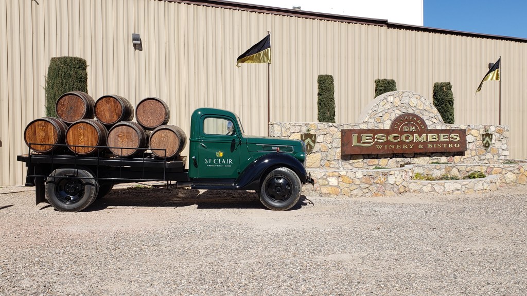
February 26; Deming, NM Since we had driven an extra 100 or so miles the first day, our second day turned out to be a short travel day of just over 100 miles. Our destination was another Harvest Host location (woohoo, free camping). We arrived at the D.H. Lescombes Winery just after noon and had our pick of spots to park our trailer. They have a huge open area that can accommodate many rigs. After firing up the generator to fully recharge our batteries for the night, Debbie and I went into their tasting room and had lunch and a wine tasting. We discovered that Debbie’s wine preference was for those that were ultra sweet. My preference was for those that weren’t sweet at all. We watched as other RV’ers came in while we spent the afternoon chatting with the workers. By the end of the afternoon, there were five or six RVs staying the night. One couple had actually been at the same dairy the night before. The night was again pretty cold, even colder than the night before. Although we had planned on it being fairly cool while on this trip, we really hadn’t planned for waking up to a 21 degree morning. Once again, we ran the generator for a bit while we fixed breakfast, showered, and packed up the trailer. Since we are heading to a state park with hookups for the next few days, we didn’t really need to get the batteries fully charged this time. So, Arizona, here we come. And we’ll have some more scenic pictures once we get there.
After leaving Gardiner, MT (Yellowstone National Park, north entrance), we just made an uneventful run back home. Our stops were one night each in Barr Nunn, WY (outside Casper), Pueblo, CO, and Amarillo, TX. We drove 1,555 miles in the last four days; NOT something that I would recommend, especially pulling a trailer! So, needless to say, we didn’t really take any pictures along the way.
We were sad to see the mountains disappear behind us as we left Colorado and headed into the flatlands of the Texas Panhandle, but all good trips must end eventually. Debbie is already anxious to line up another trip. I can say that Glacier National Park is one of the most beautiful that we’ve visited and we’ll definitely be going back.
Over the course of this trip, we drove almost 5,000 miles: 1,300 of those while sightseeing and not pulling the trailer. Diesel fuel prices were very reasonable with the exception of just a couple of places. Those were mostly adjacent to national parks or in really remote locations where there isn’t much competition. In those type of places, the price was over $3.00 per gallon. Luckily for us, there were only two times when we had to pay that much. The average price of diesel on our entire trip was $2.812 per gallon, but ranged from $2.499 to $3.17. Texas had the lowest prices by far, costing between $2.499 and $2.789 per gallon.
In the less than 18 months that we have had our trailer, it has been towed nearly 23,000 miles. We’ve been from NM to MT and UT to VA. The funny thing is that we have SO many places that we still want to see, and many to even see again.
When Debbie and I visited Yellowstone last May, several of the roads were still closed, as were some of the visitor centers. We decided to stop off for a couple of nights on our way home from Glacier National Park and visit the areas we had missed.
On Sunday evening, we arrived in Gardiner, MT, at the north end of Yellowstone. We set up at the Yellowstone RV Park, about a mile outside the north entrance. From the campground entrance, you could see the Roosevelt Arch at the north entrance to Yellowstone. This is a small campground and our site backed up right against the Yellowstone River. We also noticed Pronghorn Antelope roaming the hills just across the river.
On Monday morning, we headed into the park and drove to Mammoth, then turned east onto the roads that had been closed back in May. I saw a side road called the Black Tail Plateau Road and thought it might be something interesting like Fire Hole Canyon that we drove in May. NOPE! It was a single lane dirt road with no way to turn around. Six miles of potholes, mud, switchbacks and hills made for an “interesting” drive. Let’s just say that it wasn’t worth the half hour it took to drive those six miles.
Our drive then took us on around the northeast portion of the park and Debbie was able to pick up her Park Passport stamps for the visitor centers that weren’t open on our other visit to the park. We also stopped at several overlooks along the way. There was rain off and on throughout the day and the temperature ranged from 42 to 50 degrees, even when the sun did come out.
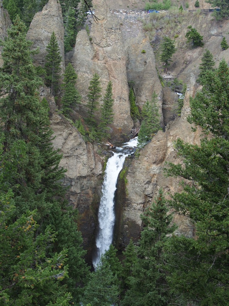
Calcite Springs.Tower Falls.
September 10, Tuesday, travel day
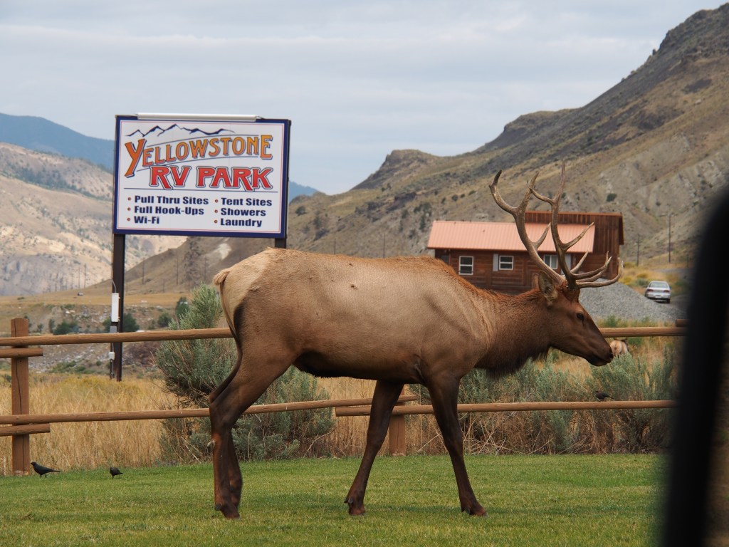
One of Debbie’s wishes for the Yellowstone stop was to finally see some elk and moose with antlers. We saw both back in May, but it was too early in the year for antlers. We saw none on Monday either, to her disappointment. We got all hooked up and started out of the campground and as we neared the highway, she got all excited and started grabbing for her phone. To our surprise, there was a bull elk standing right in front of us. She took pictures with her phone as I reached for my camera from the back seat. We both took several pictures of both the bull and several females that were standing on the other side of the highway.
Debbie was so excited to finally capture a picture of a bull elk.
With one of her two animal viewing goals reached, we drove on down to our next stop; an overnight stay in Bar Nunn, WY, just outside of Casper. Wednesday continues our dash home via Pueblo, CO and Amarillo, TX, arriving home on Friday the 13th.
Let me start by saying that it is impossible to show here all of the many (hundreds!) of pictures that we took in Glacier National Park. The place is truly spectacular and probably our favorite National Park to date. The pictures that I do post really don’t do justice to the scenery in the park. You just need to come see it for yourself.
September 6, Friday, Glacier National Park, Montana
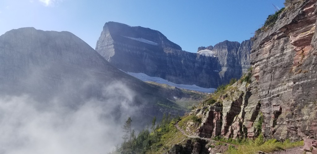
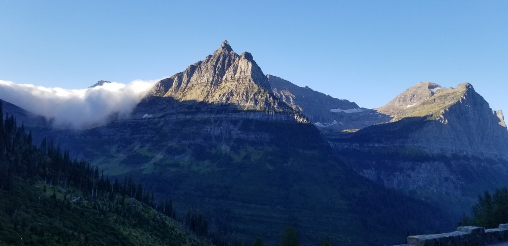
Debbie and I woke up early and found that there was a heavy fog rolling into the campground and was headed straight towards Glacier National Park, where we were also headed. As we drove into the park, the heavy fog followed us in and all the way to the Logan Pass Visitor Center in the middle of the park on the Going To The Sun Road. We started early so that we could get a jump on the people getting to the parking at Logan Pass. We’d heard that the parking lot had been filling up by 8:45-9:00 am. We pulled into the lot, completely fogged in with about 100 feet of visibility. The lot was almost full already and it was barely after 8:00! We managed to find one of the last available spots and walked over the visitor center so the Debbie could get her passport book stamped, only to find out that it didn’t open until 9:30. So, we decided to find a way to come back later in the day. Back at the truck, we continued west. Almost immediately after going through the pass, the sky opened up and was beautiful.
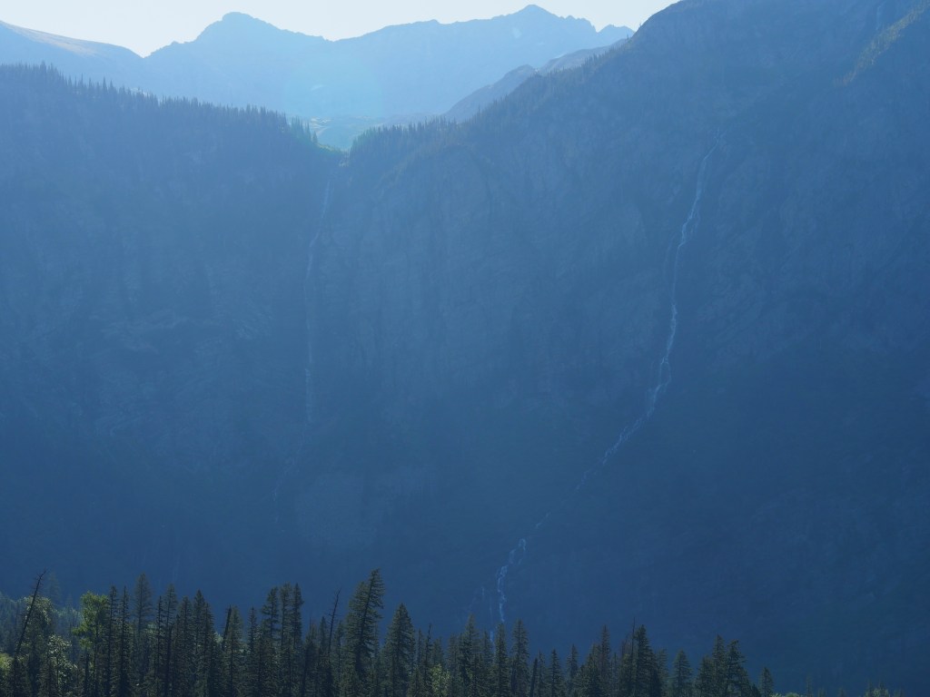
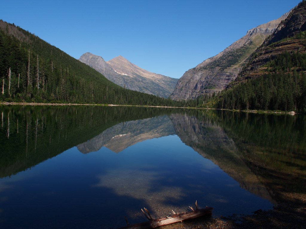
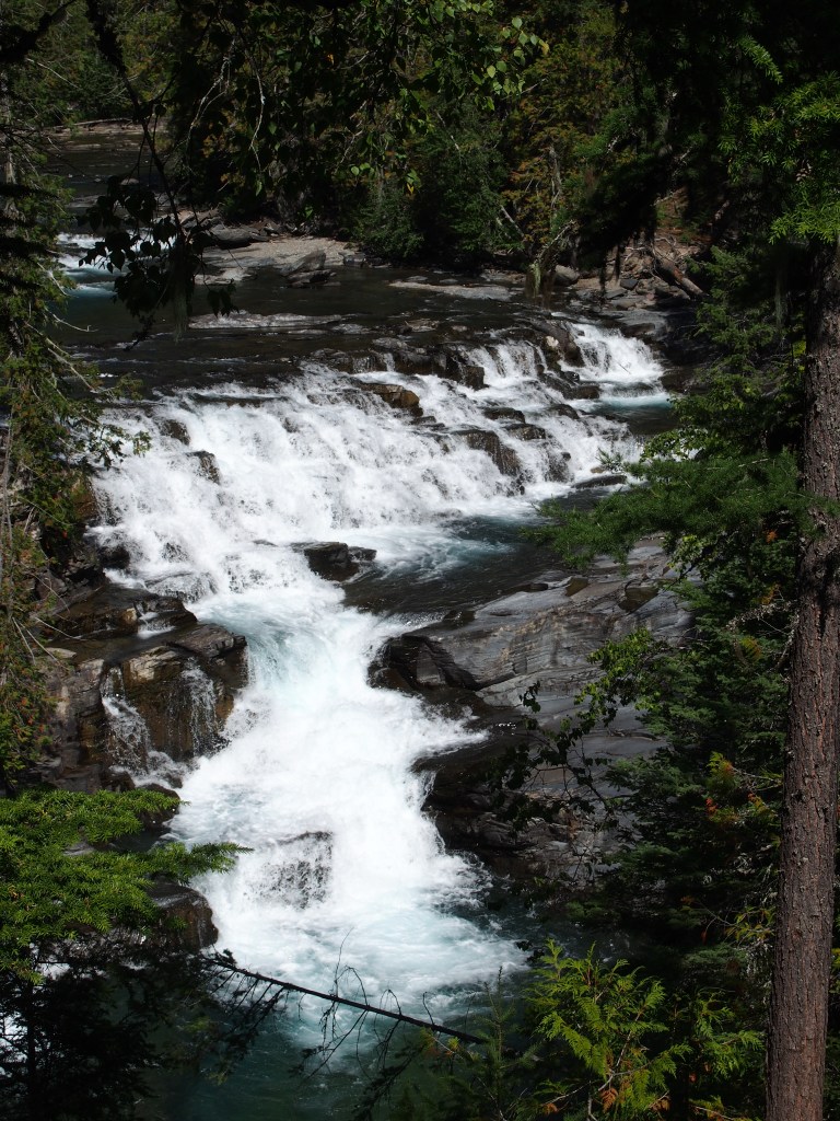
We drove down to the Avalanche Lake Trailhead and found that almost all of the parking spaces were again taken. It seemed that many people that were staying near the west side of the park were using the larger lot at that trailhead and taking the free park shuttle up to Logan Pass. I finally managed to find a spot that definitely was not made for a 3/4-ton crew cab truck, but managed to squeeze in. The trail to Avalanche Lake actually starts out along the Trail of the Cedars trail, a beautiful, fairly flat walk through a huge forest of very tall cedar trees. The temperature was perfect, at 45 degrees, for hiking. After covering about a quarter mile or so along the Trail of the Cedars, the Avalanche Lake Trail branches off, continuing though 150-foot tall cedar trees, but becoming a little more hilly. The hike to the lake covered nearly 2-1/2 miles, but rewarded us with a view of a pristine lake, surrounded by mountains, with two VERY tall waterfalls just past the lake. Unfortunately, we were so early that the sun hadn’t yet crested the mountains to fully illuminate the falls. There was a secondary trail that circled around one side of the lake. We made it the extra 1/2-to 3/4-mile to the other end in short order. The view from there, with the mountains reflecting in the calm lake were amazing. After taking a ton of pictures, we headed back to the truck to seek out another hike with some waterfalls. That hike totaled about six miles.
View from the upper end of Avalanche Lake.Two very high waterfalls at the upper end of Avalanche Lake (terrible picture, but…)
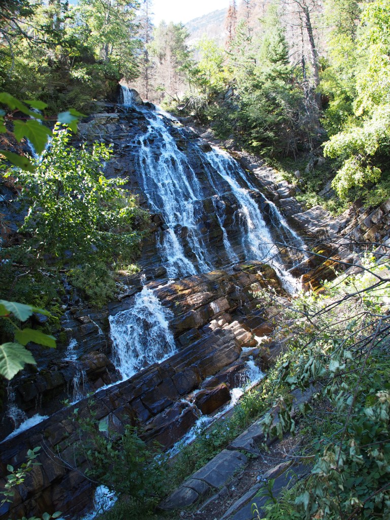
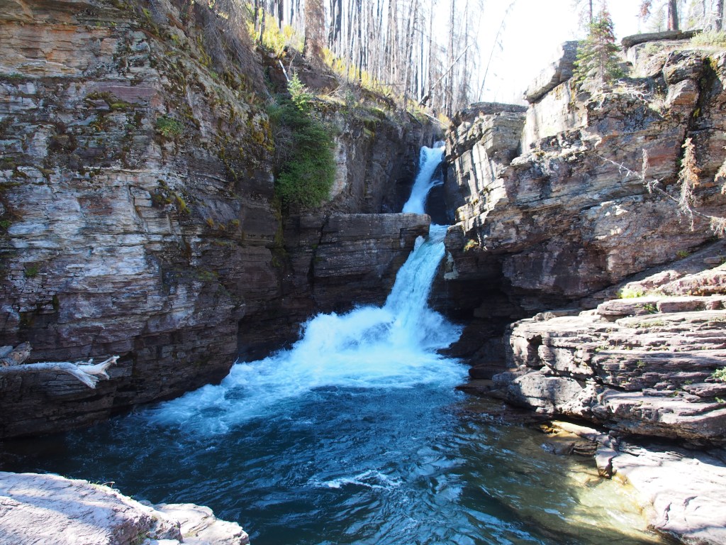
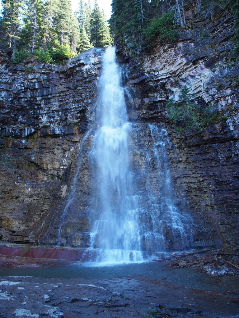
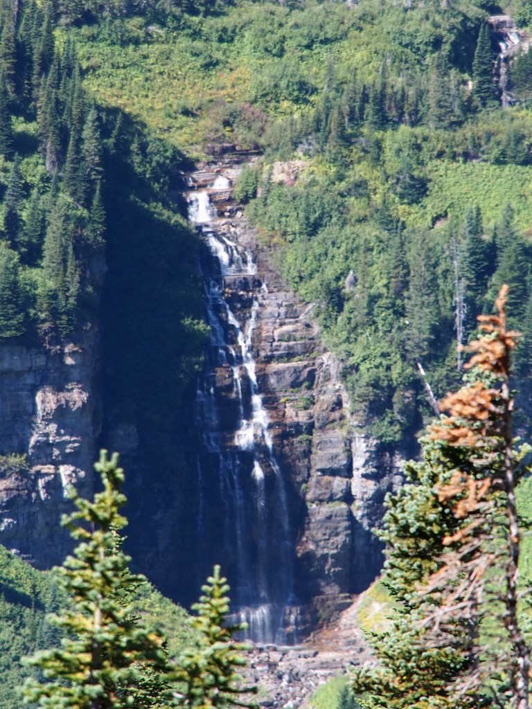
We drove back east and decided to try Logan Pass again. But again, the lot was full. Debbie ran in to get her stamp while I circled the lot looking for a nonexistent parking space. Picking her up after she was done, we headed back over to a group of that were supposed to hold quite a few waterfalls along their path. We started with Saint Mary Falls, which then led to Virginia Falls. Saint Mary Falls provided a really good view from a foot bridge just at the base of the multilevel falls. The was supposed to be a “less challenging hike”, but I would have rate it one notch higher. The trail to Virginia was rated as “challenging” and was every bit of that. It wasn’t that it was long, but it did have a good bit of elevation change. There were several spectacular unnamed falls all along the creek going to main 50-foot tall “bridal veil” type waterfall with a secondary waterfall and some cascades just below. The falling water and mist created quite a chilling effect to the air. This was an “out and back” hike, but as we neared our starting point, we branched off to a trail leading to Baring Falls. This is another cascading waterfall. Although we hiked to three named waterfalls this afternoon, there were about a half dozen really beautiful, and fairly large, waterfalls along this 5-1/2 mile hike. Total for the day, just over 11-1/2 miles.
Saint Mary Falls, over 30 feet tall.Virginia Falls, main portion about the lower cascades.
September 7, Saturday, Glacier National Park
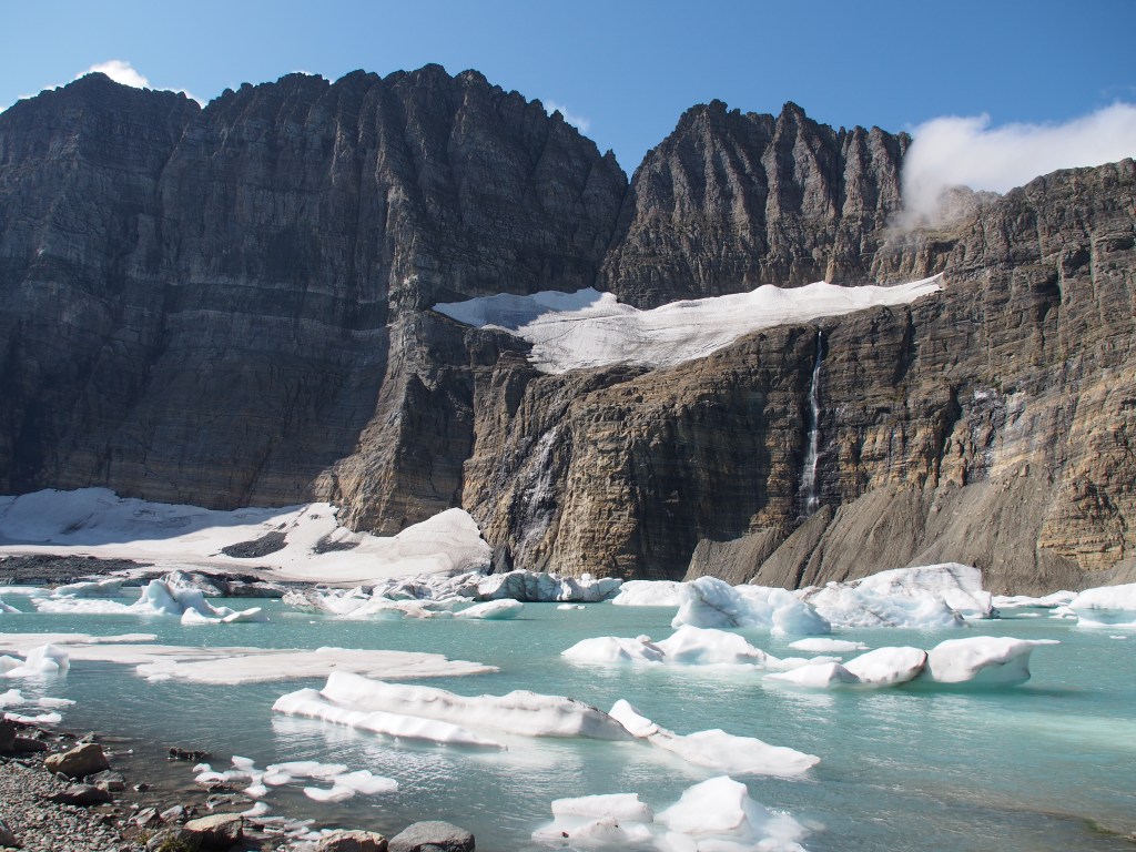
We saved our most challenging hike for our last day. We drove north into the Many Glaciers section of the park. There, we located the trailhead to the famous Grinnell Glacier Trail. This is listed as a “very challenging hike” in the parks trail guide. According to the signs at the start of the trail, it’s a 5.5 mile hike, EACH WAY, and includes a total elevation change of just over 3,600 feet. Much like the day before, it was really foggy and damp as we started our hike. Basically, we couldn’t see anything but the trail ahead of us for the first couple of miles. Luckily, as we got closer to the destination, the sky began to open up and provide some amazing views. Along the way, Debbie and I took an accidently detour that added not only extra length to an already log hike, but involved dropping down a couple of hundred feet, only to have to reaclimb that same trail. We also picked up a hiking buddy that was going it alone. Jenn DeBeers from Florida was a great hiking companion and we certainly enjoyed her company. She joined us for most of the hike up, and all of the hike back from the glaciers.
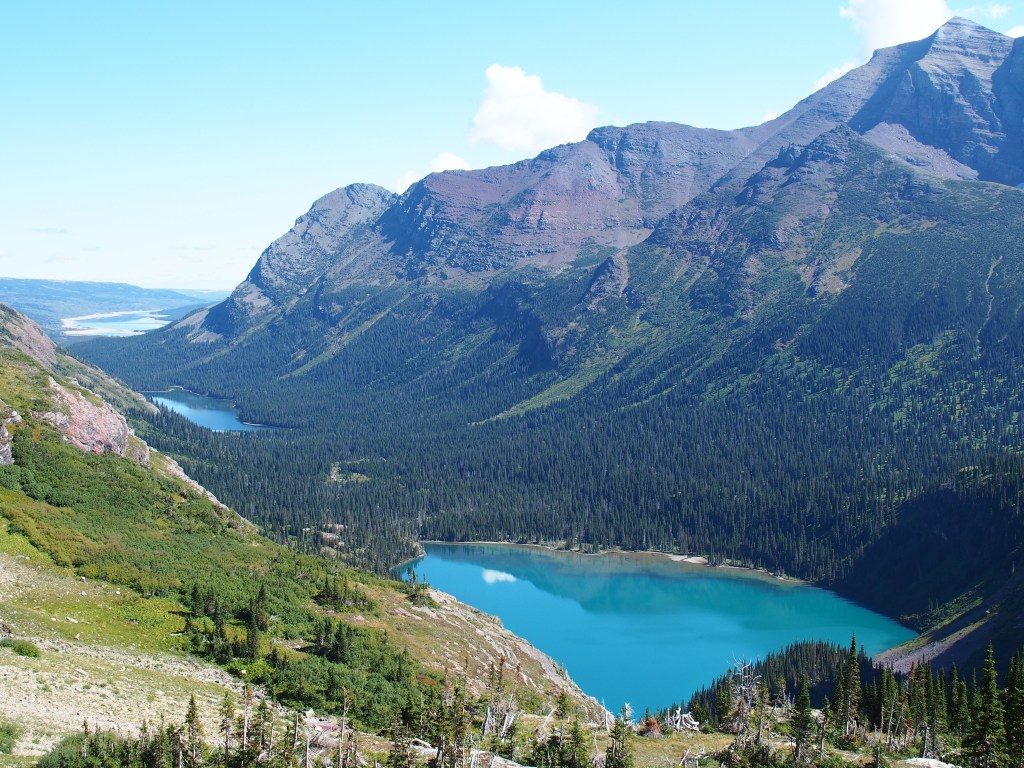
Once we broke the clouds and fog, the views were just like so many others in the park, AMAZING. Everywhere you look is like looking at a postcard. The real kicker of the hike is when you top one final crest and Upper Grinnell Lake, with its floating icebergs and Grinnell and Salamander Glaciers and several waterfalls just above, appear before you. It was so beautiful that we spend an hour just sitting and taking pictures. Over the course of the hike, we got pretty warm, even though the temperature was in the 60’s. But, sitting beside that lake with the wind blowing across it made it really pretty cold and we had to put back on the extra layers we’d pulled off just a few moments before. The hike back down provided many spectacular views. We could see all the way back down through the valley past Grinnell Lake and Lake Josephine to our starting point way off in the distance. By the time we returned to the trailhead, we had hike another 11.5 miles or so (due to our detour) and were quite exhausted.
Finally breaking through the fog and clouds on the Grinnell Glacier Trail.Upper Grinnell Lake, Grinnell Glacier (left), and Salamander Glacier (above)Grinnell Lake with Lake Josephine just beyond (trailhead was beyond that!).
September 8, Sunday, travel day
We spent the day on the road, driving from Saint Mary, MT on the east side of Glacier National Park to Gardiner, MT at the north entrance to Yellowstone National Park. We were unable to see a few of the areas of the park when we were here back in May due to both weather and road construction. We were also early enough back in Mary that a few of the park facilities had not yet been opened for the season. More about Yellowstone in my next installment.
Debbie and I woke up really early because we wanted to get into the park (Glacier National Park, for those that haven’t been following) and hit a couple of trails. We’d heard that parking was an issue at some of the trailheads, so, an early start it was to be. BUT, when I went out and started the truck, I had a error message that the exhaust filter was overloaded and that I needed to “drive to clean”. Knowing that driving into the park wasn’t going to get the job done, I decided to drive up the highway from the campground towards the nearby Canadian border and back. When this rare event does occur, it usually only takes 15 minutes or so. I drove for an hour and a half! Approximately 60 miles. The message never went away, so back to the campground we went to try and locate a nearby Ford dealership. We found that the nearest dealership in the US was well over an hour away, but also found a dealership in Canada that was only about 30 miles away. We gave them a call and they said they’d get us right in.
So, we head out to the truck, start it up and guess what? The message had changed to “cleaning exhaust filter”. We decided to go ahead and take it to get them to look at it, even though that message normally goes away in about a minute or two. Once again, no change all the way to the Canadian border, so something was still wrong. While passing through the border security, I had to put the truck in PARK, which stops the cleaning process. The message never came back on. Once at the small dealership, the tech checked the truck on the computer and told us that every thing he checked came back normal, but given the symptoms, he suggested we go ahead and do a static (manual, not driving) exhaust filter regeneration. Well, $155 Canadian and I was on my way. That’s like $115 in US.
Being in Canada, it made sense to go to Waterton Lakes National Park, which is a sister park to Glacier National Park. We’d planned on going there on Friday anyway, so why not go since we were already so close. Let me just say that Canadian national parks are not as well organized as their US counterparts. They don’t give you any information when you enter the park and signage that would normally give you directions didn’t exist. We did finally find the tiny visitor center which turned out to be in with the post office. What little roads they had were all in the town of Waterton. The only other drives were closed for repair. Pretty much the only thing there was for us to do was one hike to Bertha Falls. Using their “maps”, we finally found the trailhead. It was a very nice hike and the waterfall was pretty nice, but much of the area had been burned out in a fire last year.
Let’s just say that crossing the border back into the US took a little more effort than getting into Canada. They wanted to know where we were from (listed on my passport), what we did for a living, and since we were retired, what we did before we retired. Did we buy anything? Sell anything? Give away anything? Did we have any fruits or vegetables? Alcohol? The young man was steadily firing questions while another border agent looked in our back seat, inside our ice chest, and inspected everything in the bed of the truck. Good think I took out the propane tank and 5 gallon can of diesel fuel that I carry around.
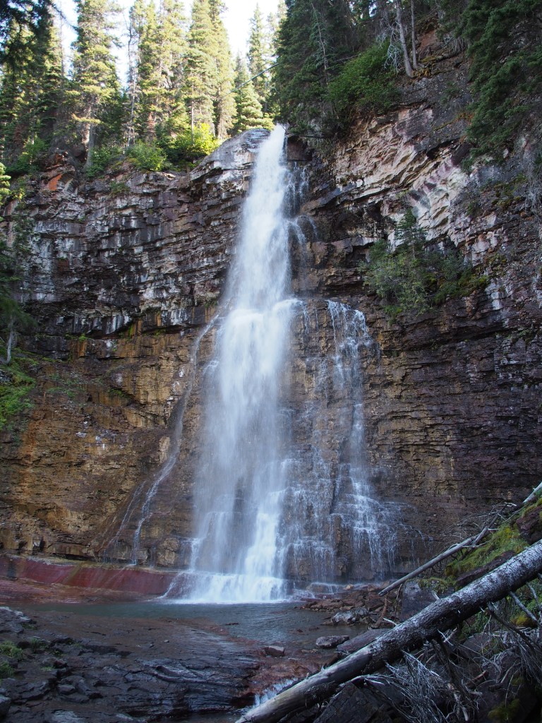
Bertha Falls in Waterton Lakes National Park, Canada.
September 5, Thursday
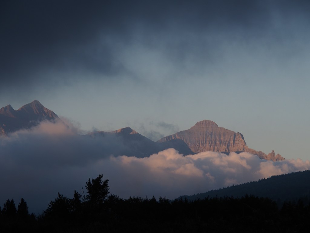
Another early morning to get back into Glacier National Park ahead of the crowds. On Tuesday, the parking lot at the Logan Pass Visitor Center was full by 8:45, so we needed to get out by about 7:00. While loading up the truck, I spotted a spectacular view looking back into the park from our campground. Heavy fog was rolling in and I thought we were going to get washed out, but it hadn’t yet reached fully into the park. Just enough to give me this spectacular scene.
View from our campground of fog rolling into Glacier National Park’s east end.
We headed into the park about 7:15 and the fog was horrible all the way from our campground to Logan Pass. We reached the parking lot at 8:10 and managed to get one of the last 2-3 spots in the lot. We walked over to the visitor center in the dense fog and 45 degree temps. This is the only visitor center in the park where Debbie hadn’t received her National Parks Passport stamp. Unfortunately, the visitor center didn’t open until 9:30! We then decided to head over into the west side of the park and try to hike the Trail of the Cedars and Avalanche Lake trails. What we found was that many, many people had decided to use the parking lot at those trailheads to catch the shuttle bus up to Logan Pass. We were very fortunate to even find a space.
Drive down from Logan Pass (which was in the fog on the left).
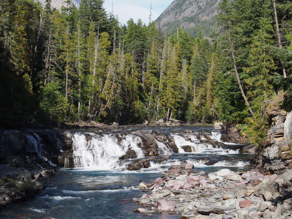
Trail of the Cedars was a pretty easy trail, partially boardwalk, that we nice and flat for those folks that weren’t really into hiking, but wanted to se the sights. We bypassed most of that and put our effort into the longer and more strenuous Avalanche Lake trail. It was a great trail through some large cedar forest, the hundred foot tall kind, and ended at a perfectly calm alpine lake. There were extremely tall two waterfalls at the far end of the lake, but our pictures didn’t work out because the sun hadn’t yet moved high enough to illuminate them. We extended our hike to walk the length of the lake to get some views with the sun behind us and were reworded with some amazing views with the mountains reflecting in the smooth lake, before heading back. Overall, this hike was just over six miles with a pretty good gain in elevation.
Avalanche Lake.
We drove back through the park, stopping briefly for Debbie to run into the Logan pass Visitor Center (while I circled the lot in the truck) to get her passport book stamped. From there, we headed back to the east side of the park to hike three trails to see some waterfalls. We started with the Saint Mary Falls Trail, then the Virginia Falls Trail, then the Baring Falls Trail. The Virginia Falls trail was by far the toughest. Although these three trails all had a named falls at the end, there were numerous beautiful unnamed falls all along the way. This hike ended up being another 5.5 miles, bringing our daily total to around 11.5 miles (over 32,000 steps on Debbie’s Fitbit!).
Saint Mary Falls.Virginia Falls.
I think we’re going to take it easy tomorrow. There is a 60-80% chance of rain, plus we want to be fresh for our final day here on Saturday where we plan on hiking the grueling trail to Grinnel Glacier up in the Many Glacier area of the park. It’s going to be an all day hike, so I hope we survive!
We got out of Hermosa pretty early, so had time to visit Devils Tower National Monument in Wyoming. The sight of the rock tower is pretty impressive, but the park is definitely lacking. Being the first National Monument in the country, you would think it would have some nice facilities. Well, no. There was very little parking and I think many of the buildings were original from 1906. There was no park video to tell you about the place, and actually no place to even show a video.
We drove on towards our final destination of Billings, MT, but did find time to stop at the Little Bighorn Battlefield National Monument long enough to check out the visitor center and watch a video about the battle. It was late, so we didn’t explore the battlefield, but Debbie and I had been there before a number of years ago when I was bowling in a tournament in the area.
We arrived in Billings just after dark and took up our spot for the night in the back parking lot of a Cracker Barrel restaurant. They set aside an area at almost all of their stores just for RV’s to overnight. We returned the favor by eating both dinner there that night and breakfast the next morning before heading out.
September 2, Billings, MT to Saint Mary, MT (east side of Glacier National Park)
There was really supposed to be nothing special about the drive to Saint Mary, MT, BUT, we found out that MT-89 between Browning, MT and Saint Mary was completely torn up. We had about an eleven mile stretch that was just gravel and was very rough. I think we drove at about ten miles an hour that whole stretch. Once we arrived at the KOA in Saint Mary, the guy that led us to our site told us that it was posted on their website not to come that way due to the construction. Well, guess who didn’t see that?
The KOA is a very nice park with the usual KOA amenities. Unfortunately, the guy in the next spot didn’t know how to park and was so crooked that our slide almost touched his. (Wish that I had taken a picture!) He was oblivious that this was a problem. Fortunately for us, the park host came by and told him that he’d have to hook back up and move his trailer. He hasn’t spoken to Debbie or me since.
September 3, Glacier National Park, Day 1
Debbie and I didn’t get the earliest of starts, but since we were going to be here for five full days, we decided that we needed the rest. This is especially true since we had covered about 875 miles over the previous two days, which was well in excess of our self-imposed 300 mile daily limit (prefer 250).
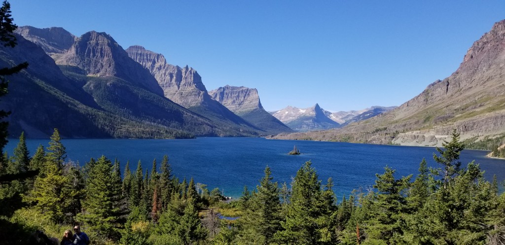
We started our park visit at our typical jumping off point, the Saint Mary Visitor Center. There, we took in the park video, visited the exhibits, and Debbie picked up her collector’s lapel pin for the park and got her National Parks passport book stamped. From there, we decided to just get acquainted with the park in the same way that everyone does; by driving the Going To The Sun Road. It’s a two lane (barely) road that often runs along the edge of a cliff for about 50 miles from Saint Mary to West Glacier, MT. We stopped at most all of the scenic overlooks to admire the many picturesque views, from mountains to valleys, to waterfalls. I think I took over 150 pictures. Admittedly, many of those were different views (or camera settings) of the same thing, but the place is so beautiful that even pictures can’t describe it.
Even though we are officially here after the busy season, with many of the facilities closing within the next few weeks, there were still plenty of people here. This meant that popular places like the Logan Pass Visitor Center parking lot was full by 8:45 a.m. We circled the parking lot a time or two, but quickly realized that there was not chance of finding a spot, so decided to continue our drive to the west end of the park and the Apgar Visitor Center. Again, Debbie got her passport book stamped, leaving only the Logan Pass Visitor Center to complete her Trifecta. Plan for Wednesday, September 4, was to hit a few of the popular hikes inside the park, but things worked against us once again. That saga will be a tale for the next blog.
Please feel free to comment (or criticize) below or make any suggestions that might help me to make this interesting.
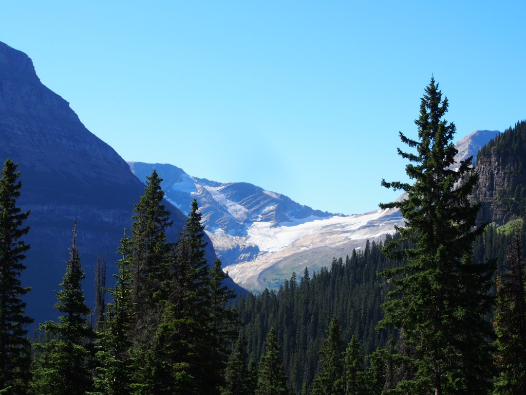
Wild Goose Island.One of only 26 remaining “active” glaciers in the park.Just one of the many waterfalls in the park.A “less scary” section of the Going To The Sun Road.OLYMPUS DIGITAL CAMERA
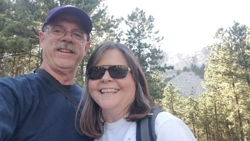
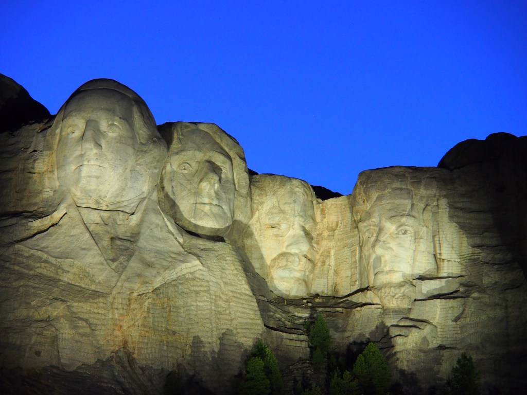
I shared in my last post how we arrived in Hermosa, SD, just south of Rapid City, just after lunch on Wednesday. Since we got in and hooked up fairly early, we decided to go ahead and take in Mount Rushmore National Memorial. The drive up was beautiful, but I was really surprised that our National Parks Annual Pass did not gain us entrance. We had to pay $20 to park. The other downside of our visit was something that we knew about going in. The visitor center, amphitheater, Avenue of Flags, and a portion of the Presidential Trail were closed for maintenance. But, we were able to take the open portion of the Presidential Trail right up to the base of the mountain. We stayed until nightfall and saw the ranger presentation and lighting of the statues. It was a truly amazing sight.
Mount Rushmore in the background.Mount Rushmore at night.
August 29
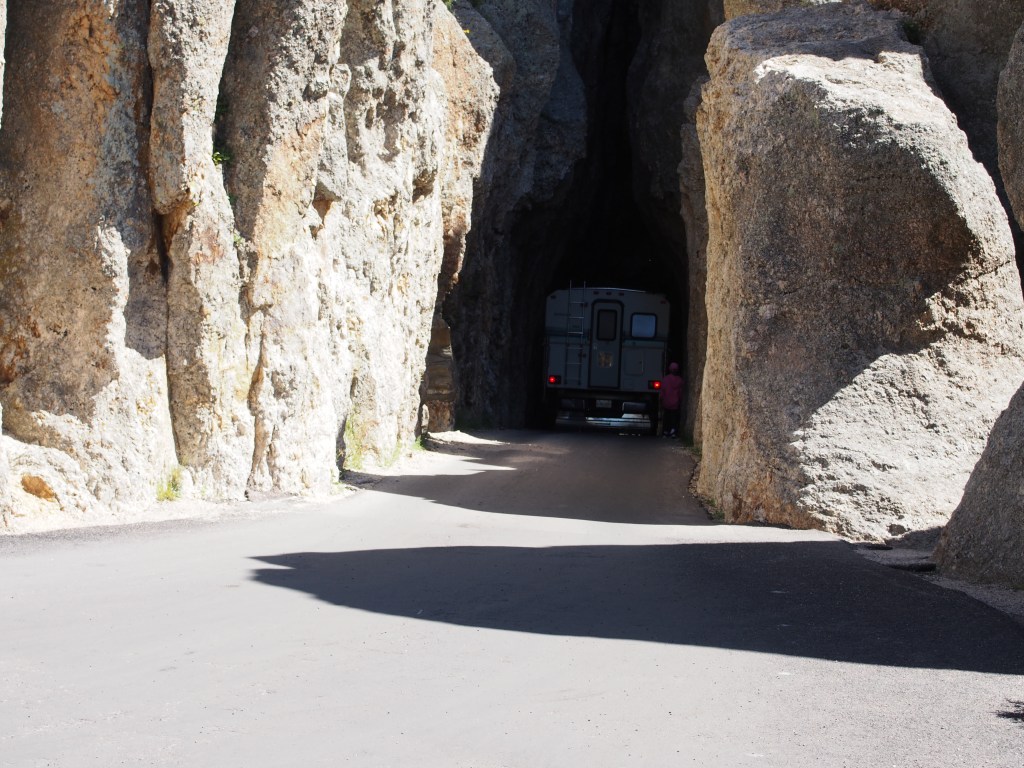
We started our day with a drive up to Custer State Park. This is one of, if not THE, largest state park in the country. I will say that it’s one of the most beautiful and awe inspiring parks we’ve ever visited. The drive through the park offers many spectacular views, but be aware that the roads are very, very narrow and twisty. There are also several sections that include very narrow tunnels. We witnessed one guy in a small Class-C camper squeeze through one of the tunnels with almost no room to spare. I had to fold my mirrors in just to keep them from scraping the sides.
We didn’t think he was going to make it.
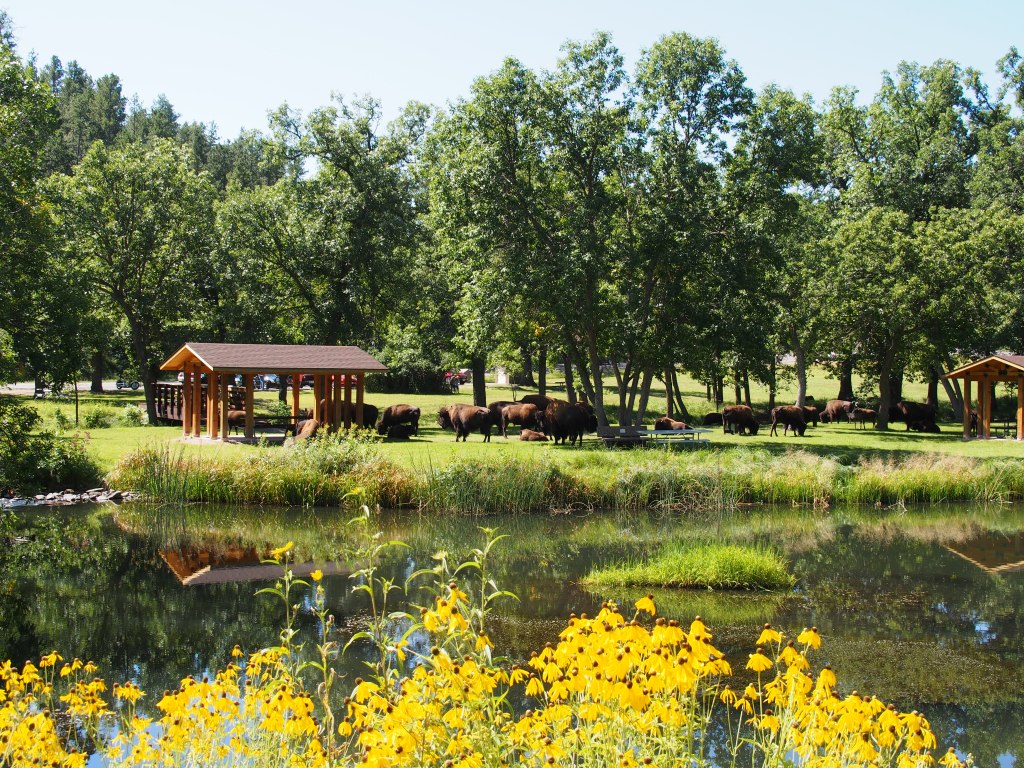
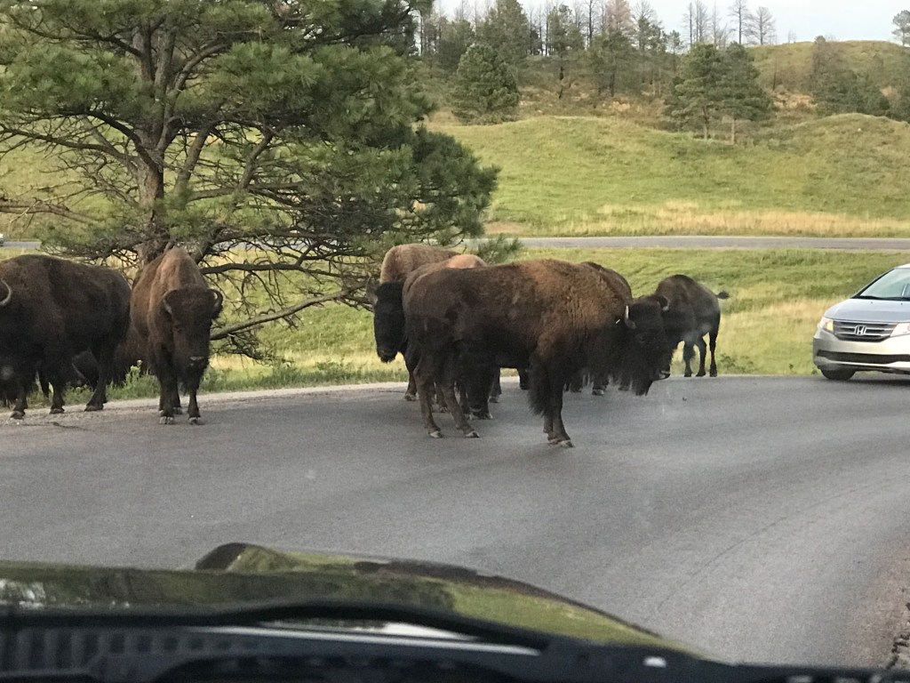
There was a very large herd of bison that took over the picnic area at the visitor center. The ranger told us that the bison hadn’t been down in that area since last May. We watched the video in the visitor center and continued our drive through the park. We then drove to the town of Custer for lunch at the Black Hills Burger and Bun Company (at the recommendation of the Woodwards). The food there was great!
Bison took over the picnic area.
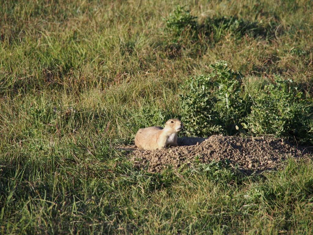
Since there was still some time left and we weren’t too far away, we made a run down to Jewel Cave National Monument so that Debbie could get her National Parks passport book stamped. We went in spite of the fact that the elevators were down at the cave and the only tours were the more primitive lantern tours that we didn’t care to take. After getting her book stamped, park stickers and lapel pin (Debbie collects them) purchased, we realized that we had time to make the drive over to Wind Cave National Park. Unfortunately, due to repeated instances back in June of people getting stuck in their elevators, those had also been shut since the first of July. We talked to the Ranger and decided to take a hike on the Rankin Ridge Trail, the highest point in the park. Upon arrival, we discovered the parking area was adjacent to a huge prairie dog village. As we walked by on our way to the trailhead, the prairie dogs were going crazy “chirping” at each other in warning. The trail, while pretty steep in places, did offer some great views to the east with the Badlands in the far distance. Leaving the park, we encountered a large herd of bison that had decided that the park road was a great place to just hang out. We patiently waited for a chance to get by them, and while doing so, one of them decided to use the front of my truck for a scratching post.
Just one of the THOUSANDS of Groundhogs we saw.Bison roadblock.
August 30
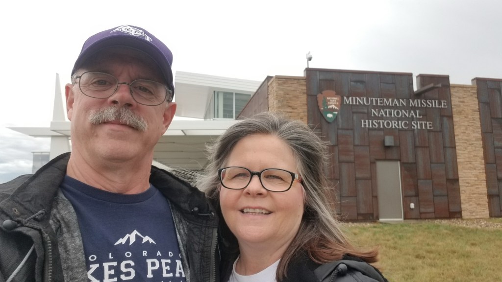
We woke up on Friday to rain. After waiting a couple of hours to determine when it might end, we then drove to the Bandlands National Park. Once again, park video, lapel pin and park sticker purchase, and passport stamp were the first things we did after arriving at the visitor center. Keeping an eye on the weather, we kept seeing that the rain was supposed to end “in under an hour”. While waiting on the rain to stop, we drove a few miles to the Minuteman Missile National Historic Site. This is a fairly new facility and had several movies and some really great exhibits about the nuclear missiles that were housed under the northern plains area of the United States during the Cold War.
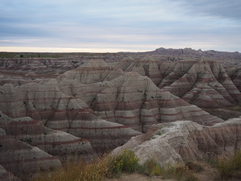
Since the rain seemed to be a repeating story for much of the day at Badlands, we decided to take a couple of short hikes in the rain. The most spectacular of these was the Notch Trail, which included a pretty steep climb up a ladder made from logs and cables. Going up that ladder was pretty intense, especially in the rain, but even more harrowing climbing back down. The views from the top were just like so many we’ve encountered in South Dakota, absolutely beautiful. That hike was 1.5 miles, round trip.
Once the rain finally did stop, we followed up with a much longer hike down the Medicine Root trail through a vast prairieland, to Saddle Pass trail with a spectacular view over the valley below, then took a portion of the Castle trail through the intricate rock formations back to the truck. That hike was about 4.2 miles.
Debbie attacking the log ladder.Just some of the wildlife we saw at Badlands National Park.Once of the MANY great views of the Badlands.
August 31
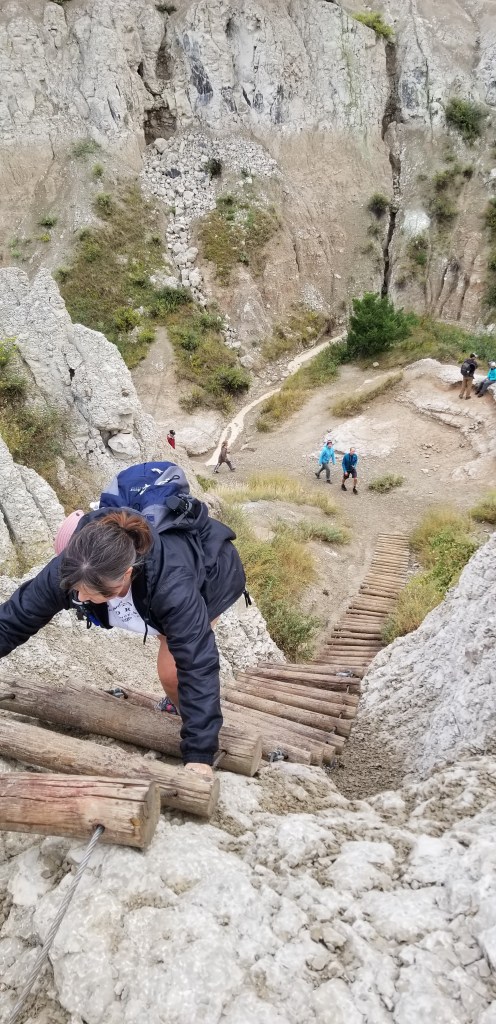
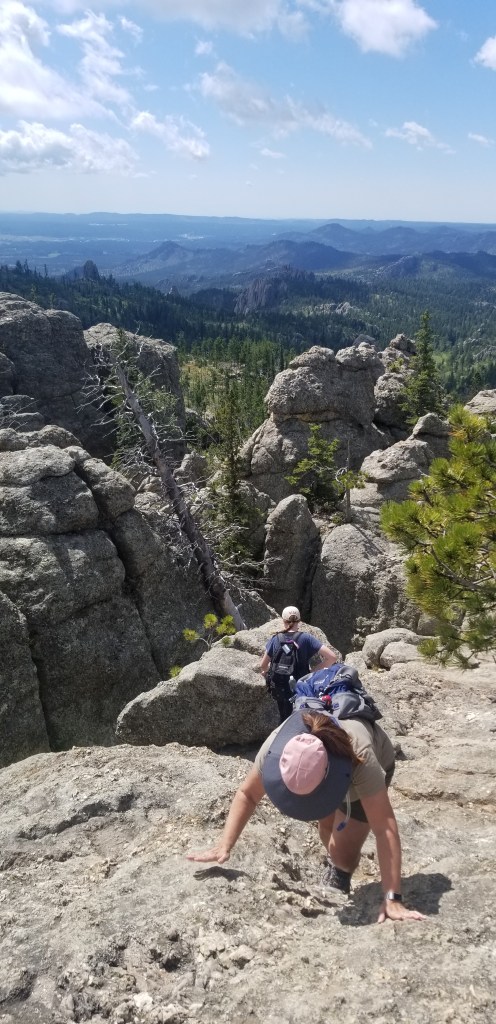
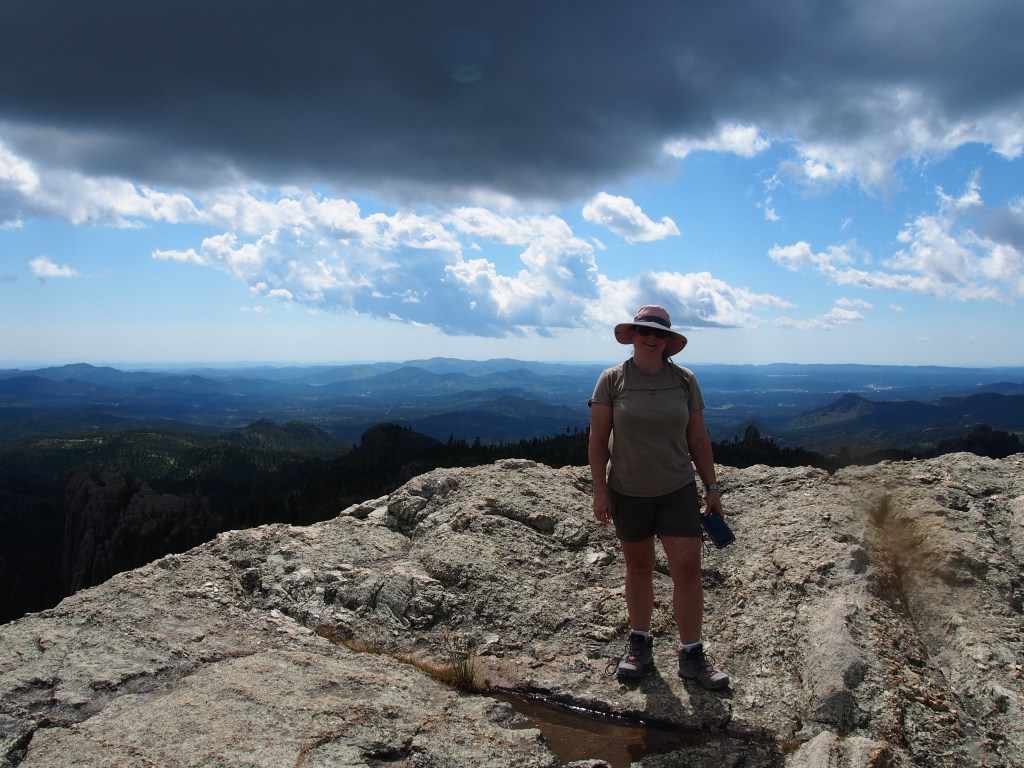
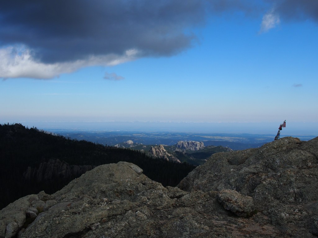
Our last day in South Dakota was planned to be a return to Custer State Park to do some hiking. After some research, we picked out several trails that were regarded as the more impressive ones in the park and headed that direction. Let me tell you, Saturday of Labor Day weekend sure brought out the crowds! That place was packed. We were able to find a parking spot at the Little Devils Tower trailhead. This 1.2 mile trail (one way) involved a fairly high climb to a point on a huge rock with 360 degree views. The only p0int that was higher than we were was Black Elk Peak, formerly known as Harney Peak, which is the highest pint in South Dakota and reportedly the highest summit in the United States east of the Rocky Mountains. (I guess they don’t place Guadalupe Peak in West Texas as “east of the Rocky Mountains” since it is over 1,500 feet higher.) The last portion of our climb involved scrambling over boulders, near rocky ledges, and through crevices to reach the very top. Photographs doesn’t do it justice. I’m very proud of Debbie that she was able to conquer some of her fear of heights and make it to the top.
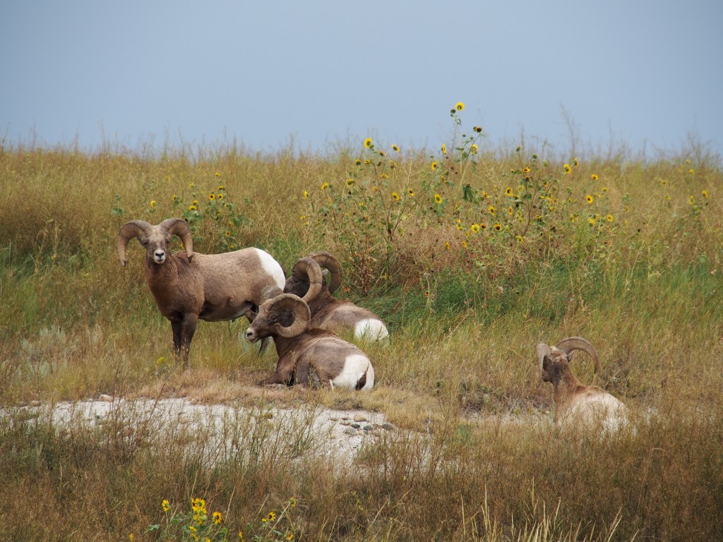
We then added as side trip along the Cathedral Spires trail. The spires were very impressive and we even saw some people climbing them. We also encountered a Rocky Mountain Sheep along the trail back to the truck. We finished the day off with a really beautiful hike around Sylvan Lake.
Making our way to the top of Little Devils TowerAtop of Little Devils Peak.View from the top of Little Devils Peak.Just one portion of Cathedral Spires.More wildlife in Custer State Park.
We made it back to the RV park in time for a hamburger and BBQ chicken sandwich dinner and some live music at the campground’s event center. Then, back to the trailer to get ready for our trip tomorrow to Billings, MT. We hope to make stops along the way at Devils Tower National Monument in Wyoming and possibly the Little Bighorn Battlefield National Monument in Montana.
Since we were melting in the Texas heat, we decided to take our trailer and take a trip north in search of cooler weather. The forecast for Gordon on Monday, Aug. 26 was 106, so that looked like a great day to start our journey. We started out with a run through the panhandle, but even after driving for 458 miles, we didn’t quite make it out of Texas. We ended up stopping in Stratford, just south of the Oklahoma border, due north of Amarillo. It seemed like we were bucking a brisk wind the whole way and our fuel mileage was horrible. With my tiny 26 gallon fuel tank and 7-1/2 mpg, we were stopping for diesel about every two hours!
We located an interesting park right off US-287 that was basically a gravel parking lot, but did have 60 full hookup “campsites”, including WiFi. It was called the “Star of Texas RV Park”, but it wasn’t very fancy. There were no camp hosts or staff onsite (or trees, for that matter). You just paid $30 at a kiosk at the gate and then went to whatever open site you wanted. There were about 50 or so to choose from so we picked out one of the most level sites we could find. Definitely not glamorous, but it served it’s purpose. Oh, and it was ONLY 90 degrees there, so definitely cooler than at home.
On Tuesday, we started out with high hopes of better mileage as we began our 420 mile leg to Cabela’s home town of Sidney, NE. Forecast high for the day in Sidney? 75 degrees!! Well, fuel mileage did improve, but only very slightly to 9.1 mpg. In addition to that, I was getting a message that the truck was “Cleaning Exhaust Filter” about every 100 miles. Something was definitely wrong that was going to need to be addressed before we went too much farther. So, we pulled into Cabela’s for the night and went inside to hopefully not spend too much money. We got out of there relatively light, ate some Mexican food across the street, and retired for the night. We opted to stay in the free “bookdocking” area which ended up being parked with more truckers than RV’ers. Lucky for us, the semi that pulled in next to us at about 10:00 was a reefer. So, his cooling unit ran all night right outside our bedroom window. Guess what pulled in on the other side of us about 1:00 a.m.? You guessed it, another reefer! Serves me right for passing on the actual RV campground that Cabela’s had onsite because the area we were in was “more convenient.”
On Wednesday morning, as we pulled out of Cabela’s, fueled up, and started down the road, I noticed that one of the truck tires was low. Also, with the cold weather (62 degrees), the trailer tires were all about 4-5 psi low. Since access to the air at the gas station was virtually nonexistent, I pulled out my new Viair RV compressor. I’ll just say that the Viair is an awesome purchase. Fast, quiet, and had everything necessary to reach all of the truck and trailer tires without moving the pump all over the place.
Since Sidney, NE has no Ford dealership, we started looking for the nearest one on our route to our next destination of Hermosa, SD (just south of Rapid City). Well, it was nearly two hours away in Alliance, NE. I called as we were leaving Sidney and was told that they would get us in just as soon as we got there. Upon arrival, the dealership was a small place (but still much larger than Stowe Ford in Gordon) and didn’t have a parking lot big enough for our rig. So, I turned on a side street, found a vacant gravel lot to pull into, and started walking over to the dealership. I was met by a service tech long before I even got across the street. He helped me unhook and had my truck in their service area before Debbie and I could get into the building. They felt that the truck needed a “static regen”. If you’re familiar with diesel trucks, you’ll know what I’m talking about. Otherwise, just imagine them charging you $150-200 to burn up a bunch of your own fuel. After they were all done, the service manager came in to give us the good news. The problem was actually caused by a problem that was on a Ford recall. Total cost to us, ZERO!
With that, we topped off our fuel and headed on towards Hermosa where we are staying at the Heartland RV Park for four nights. Checking fuel mileage for that last 134 miles would have been a good idea, but once we got our RV set up, we were early enough that we decided to head over to Mount Rushmore without topping off the tank. Once we got back and did top off, the combined mileage on that tank was 11 mpg (69% towing, 31% not towing). I guess we’ll find out when we leave here on Sunday how our “free repair” worked out as far as fuel mileage goes.
Since the first few days were mostly traveling, there really aren’t any pictures to share just yet. The next few days will cover many of the attractions here in the Black Hills area; Mt. Rushmore National Memorial, Jewel Cave National Monument, Wind Cave National Park, Custer State Park, Badlands National Park, and a couple of others that have slipped my mind. Check back in a couple of days for the take on those places and I promise that there will be some pictures.