New England, 2022

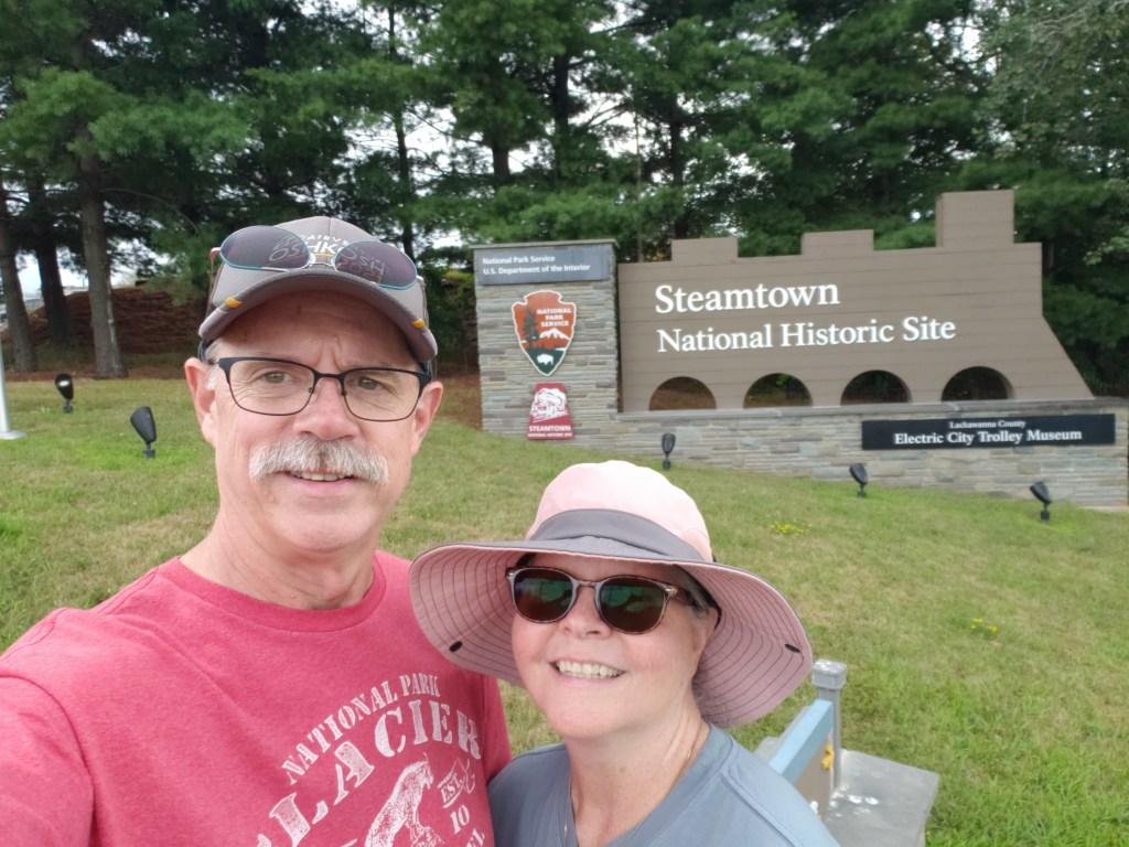
Post #5: Southwestern Maine, August 18 to August 24.

From Plymouth we finally move into Maine. We started with a Boondockers Welcome site for three nights. For those that don’t know, Boondockers Welcome is like a Harvest Host, but where you can stay for multiple nights, and is a way to stay places for free. In this case, we were able to park our rig at Grace Point Church in the small down of Biddeford. The church allowed up to three RV’ers to park around the perimeter of their parking lot. We weren’t alone there as several other travelers stayed there during our three nights there. One of the other couples that we met there were Chris and Marci Felker. They are full-timers that sold their house in Forney, TX before hitting the road just a few months ago. It turns out that they’re taking much of the same path as us over the coming weeks, so we’re sure to cross paths again.

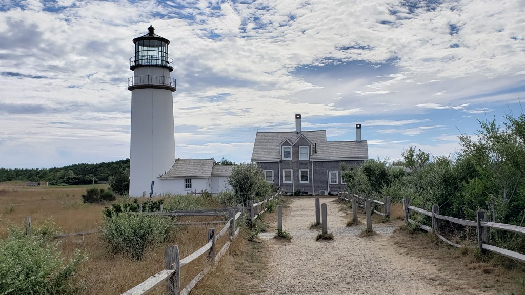
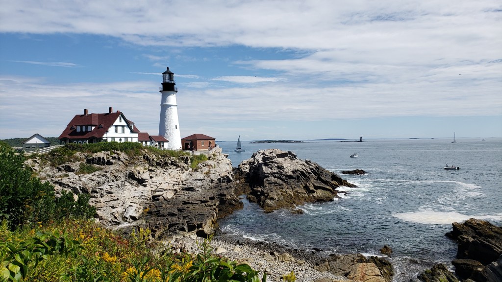
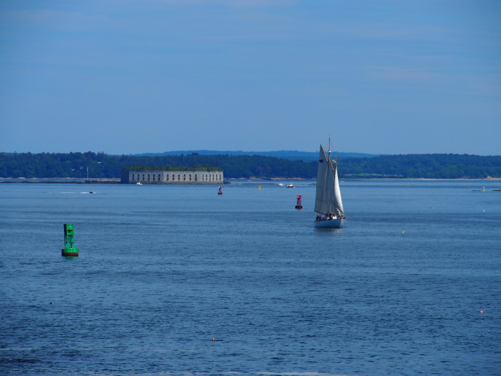
While staying in Biddeford, we got our first real views of coastal Maine in Portland by going to the Portland Head Light. This is the oldest lighthouse in Maine and was originally built in 1791. Its purpose was to protect ships on the main channel into Portland. While in the area, we visited some of several old forts that also protected Portland over the years. There were several gun batteries located around the lighthouse, but there were several other forts protecting Portland Harbor.

Portland Head Light.
Ft. Gorges in Portland Harbor.

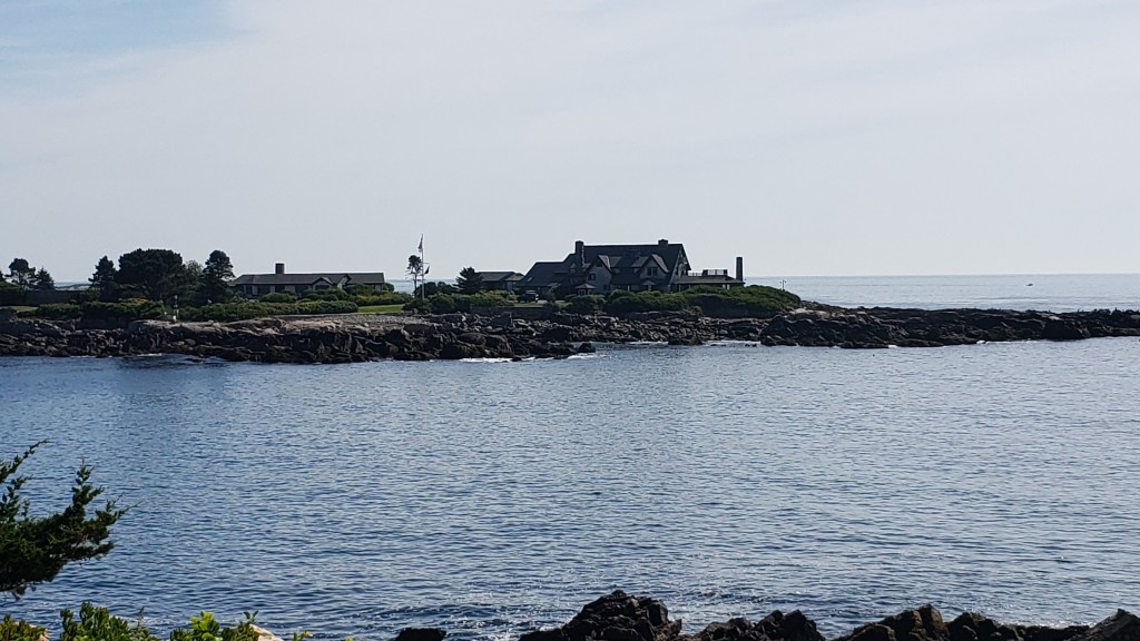
On Saturday we visited Kennebunk and Kennebunkport. The two really seem to be just one town, divided only by the Kennebunk River. Since we got there so early, we first took a two mile each way walk along the shore down to the Bush family compound on Walker’s Point. As we walked past St. Ann’s By-The-Sea Episcopal Church, we noticed that the entrances to the church were blocked off by black SUVs and wondered what might be going on. As we got closer to the viewpoint that overlooked Walker’s Point, three of those SUV’s drove by and pulled into the compound. We could see what must have been some of the Bush family get out of one of them over at the house while the other two stopped at the front gate.

Bush family compound on Walker’s Point in Kennebunkport.

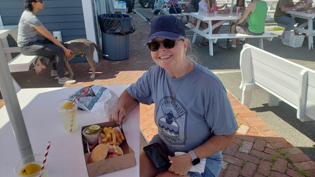
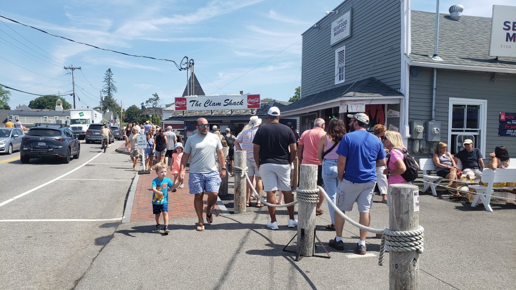
From there, we walked back to town where Debbie was able to get a lobster roll at an iconic little place called The Clam Shack that’s been selling award winning lobster rolls since 1968. The place looks almost like a food truck, but it turns out that they own several buildings at the location where they cook and “hand pick” fresh (caught that morning) lobster every day. A line forms at 11:00 a.m. and seems to stay full all day. Debbie ordered hers with “both”, which is melted butter AND mayo. That combination is the recommended method of preparing the sandwich and the secret to his success and was really good, even though I’m not really a lobster person.

Debbie’s Lobster Roll lunch from The Clam Shack.
This line lasted all day.

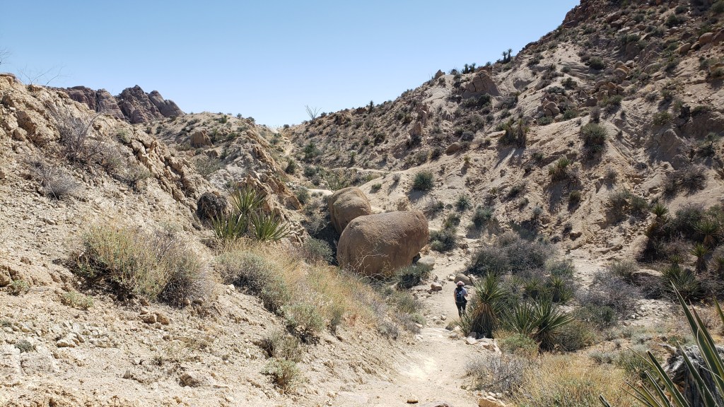
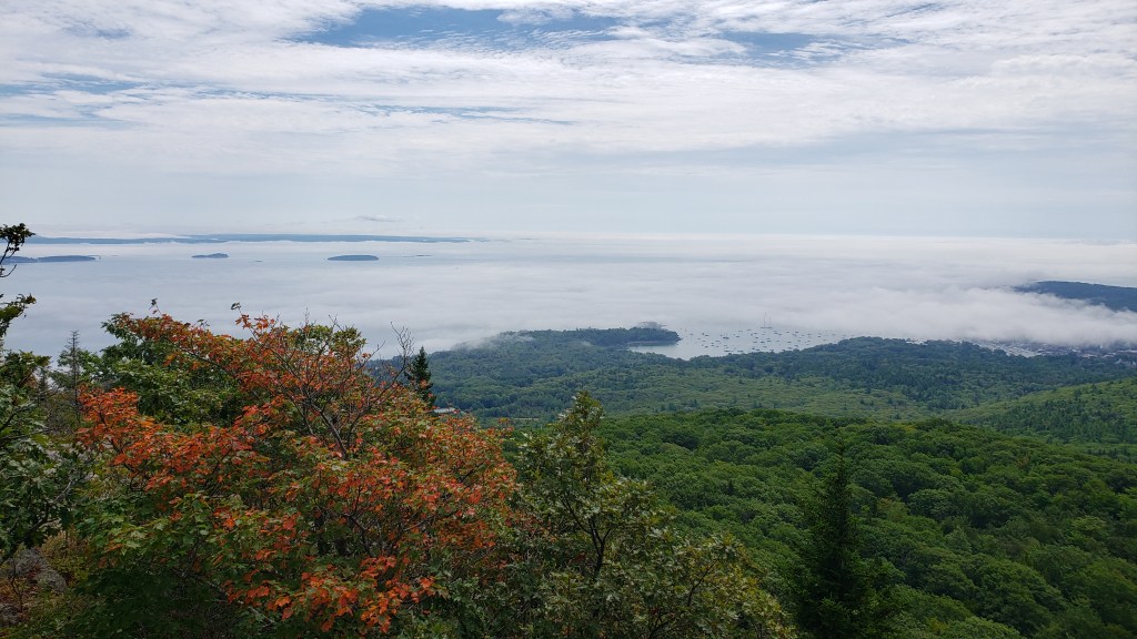
On Sunday morning, we drove up to Camden Hills State Park. We had a no hookup reservation there, but hoped we’d be able to score one of their first-come, first-served water and electric sites. Unfortunately, we were not able to and ended up in our reserved, but very tight spot that was completely covered by trees which prevented us from being able to get use of our solar panels to keep our batteries charged. We were able to run our generator for a few hours each day to keep everything charged up. We started our time there with a hike to the top of Mt. Magunticook with a climb of just over 1,000-feet, then back down and another 600-foot climb to the top of Mt. Baddie. It was quite a trek, but the view of Penobscot Bay and Camden Harbor were quite impressive.

Foggy view of Penobscot Bay and Camden Harbor from Mt. Megunticook.

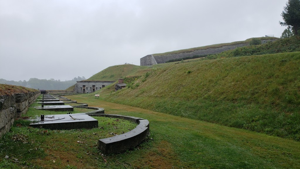
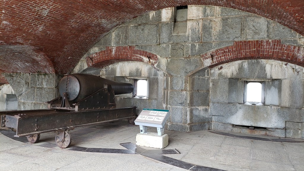
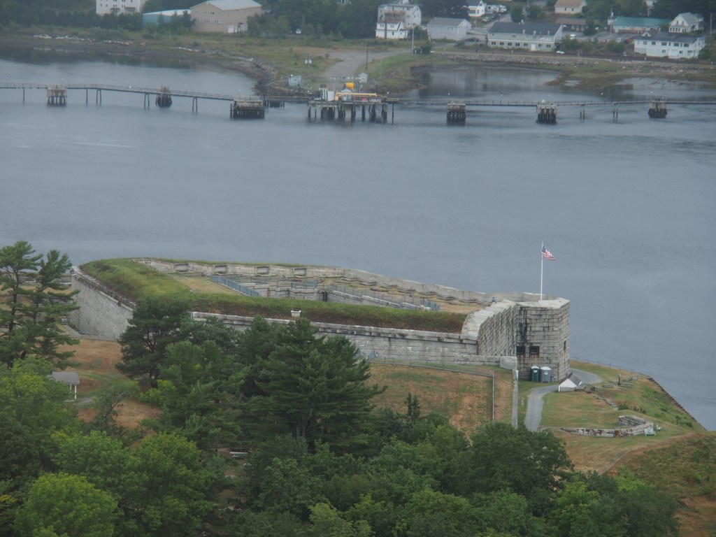
In spite of a fairly persistent rain, on Tuesday we visited the original Ft. Knox which guarded the Penobscot River which connected Bangor with the sea. It was decided that a fort was needed in that area after the British occupied that part of the state during the war of 1812. Both Ft. Knoxes were named for Major General Henry Knox who was America’s first Secretary of War and was Commander of Artillery during the American Revolution. Even though the fort was built with mounts for 135 large cannons, no more that 74 were ever in place. Surprisingly, the fort only housed 575 troops for one month during the Spanish-American War and between 20 and 54 troops for a time during the Civil War. In a way, it reminded me a lot of the smaller Ft. Nelson at the Dry Tortugas National Park in the Florida Keys.

Battery B with the main building of Ft. Knox in the background.
One of the fort’s gun emplacements.

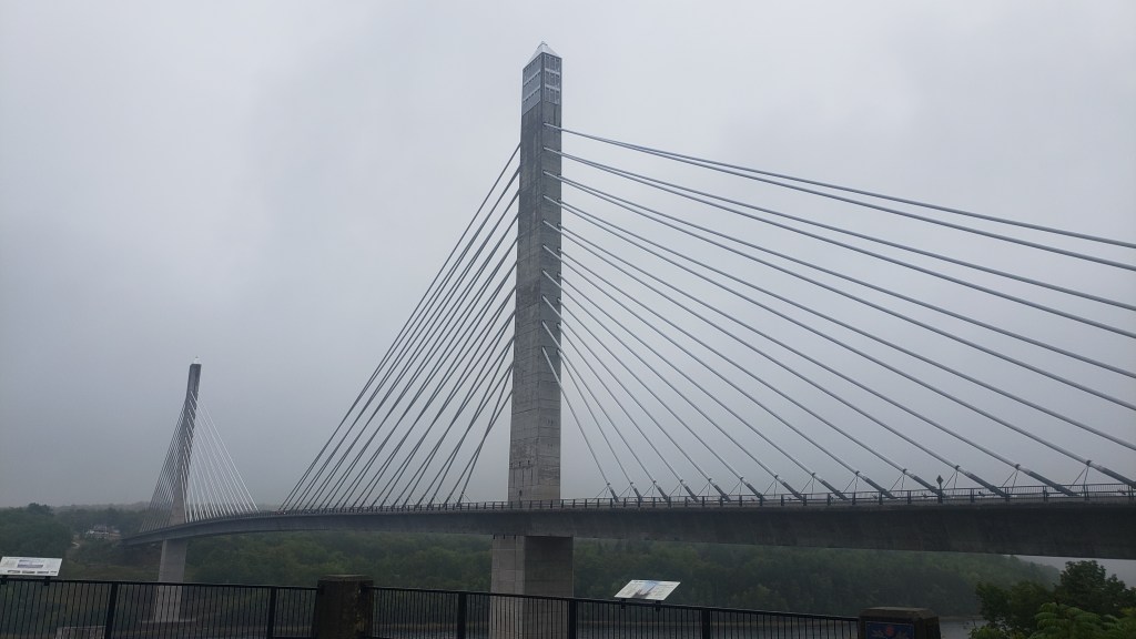
Adjacent to the Fort Knox State Historic Site was the Penobscot Narrows Bridge and Observatory, one of only four bridge observatories in the world and the tallest at 420-feet. You get to the top aboard the fastest elevators in Maine at 500 feet-per-minute. The view at the top of the Penobscot Narrows, Bay, River, and the adjacent Ft. Knox was pretty amazing in spite of the fog and clouds.

Penobscot Narrows Bridge with observation deck in the near tower.
View of Ft. Knox from the observation deck.

From Camden, we moved still farther up the coast to Bar Harbor and Acadia National Park. More to come on that location.

New England, 2022

Post #4: Southern Massachusetts and Rhode Island, August 14 to 18.

From the Catskills, we moved over to Plymouth, Massachusetts, just south of Boston. We found a nice, heavily wooded campground with lots of room between spaces. The campground is fairly central to the things that we’ve wanted to visit, Plymouth, Cape Cod, and Newport, Rhode Island. As you know, we use our “camping” spot to put us into the general areas that we want to visit, then fan out up to about an hour to see the sites. This stop was no exception.

We started out Monday morning by driving the short distance into Plymouth. Finding free parking at a city park got us off to a good start. After a very short stroll on a park path along a creek, we found ourselves right at that iconic spot that every tourist has got to visit, Plymouth Rock. Supposedly, it is a piece of the actual rock upon which the Pilgrims actually landed in 1620. Over the years before the rock was protected, tourists would chip away pieces as souvenirs to the point that it’s now about a third of the size that it once was. From there, we walked the town, took pictures of the Mayflower II (another touristy spot), visited a museum about the history of the town, and strolled through the cemetery that even has some of the original settlers buried there.

Plymouth Rock.
The Mayflower II.
Plymouth Harbor.

We left from Plymouth and headed in a generally easterly direction out around Cape Cod to the Cape Cod National Seashore. There were two National Park visitor centers that had multiple videos that we took in before checking out the great views of the coastline, lighthouses, and ocean. The second visitor center was in Provincetown, at the tip of the Cape Cod peninsula. On the way back, we also visited the Highland Light (lighthouse).

Highland Light on Cape Cod National Seashore.

On Tuesday, we drove back about an hour southwest to Newport, Rhode Island. Parking there was expensive ($8/hour), but we found out from the guy at the Newport visitor center that we could park at the transportation center and if we rode the free shuttle bus around town, that we could get our $20 parking charge reduced to just $2 for the whole day. Of course, we did park there and used the free hop-on/hop-off shuttle bus to get us around town. Using the shuttle bus, we rode down to the Bellevue Avenue area where many of the ultra-rich built summer “cottages” along the shoreline where they would spend just a couple of months each summer. We toured three of the Gilded Age homes, all of which were extremely over the top. The first home we visited was The Breakers, completed in 1895 by Cornelius Vanderbilt II who was one of the richest men in America at the time. It’s the largest of the cottages with 70 rooms, including 48 bedrooms for family, visitors, and staff. It even has 27 fireplaces, even though the house has central heat. The house includes 138,000 square feet and cost $11M to build in 1895.

The view of The Breakers from the back yard.
The Grand Hall at The Breakers.
The Music Room at The Breakers.

We followed that with a short walk along the famed Cliff Walk that hugs the shoreline behind all of the mansions. We walked to The Elms, completed in 1901 by coal magnate, Edward Berwind at a cost of $1.5M. While much smaller at ONLY 60,000 square feet, it was another beautiful example of the Gilded Age mansions. Even though his riches came from coal, we were amazed to find that the stove in the kitchen remained lit and ready for use for the entire “season”, several months during the summer, and burned 30 tons of coal each summer. He didn’t want coal or ash trucks to be seen on the property, so he built an underground access to another street for the trucks.

The Elms.
The dining room at The Elms.
Just inside the entryway of The Elms.

After touring The Elms, we again rode the free shuttle down to what may have been the most opulent mansion in Newport, even if it wasn’t the largest. Marble House was built by William K. Vanderbilt and the 50-room house was completed in 1892 at a cost of $11M to build and furnish. Vanderbilt spent over $7M just on the marble used to build the house. And remember, this was in 1892! Every room was floor to ceiling marble. Upon completion, William gave the house to his wife for her 39th birthday. The large “Grand Salon” ballroom’s walls were completely covered in 22-karat gold leaf, giving it the moniker of “The Gold Room”. The chairs in the dining room were bronze, covered in gold, and weighed 75 to 100 pounds each, with a footman stationed at every one of the dozen or more chairs just to move them in and out for the dinner guest. After later divorcing William and marrying another millionaire that lived nearby, Alva left the house and only used it as storage for her many dresses (women changed up to seven times a day). She also kept the laundry open because she felt that it was better than the one in her new mansion.

Entrance to Marble House.
The dining room at Marble House.
The “Gold Room” at Marble House.
The “Gothic Room” at Marble House.

If you’ve never been to Newport and toured the mansions, sorry “summer cottages”, I highly recommend it. Also, the town of Newport is a great place to visit in itself. Tons of amazing restaurants.

New England, 2022

Post #3: Catskills Area of New York, August 11 to 14

On Thursday, we moved a little bit farther east to Plattekill, NY, about 75 miles north of New York City. While we would like to visit NYC at some point, it’s not on our agenda for this trip. We stayed in another KOA, but this one is not like most. It’s more like a state park and our site is surrounded by trees and space between us and our nearest neighbor. We were pleasantly surprised.

Our first day started with a trip down to West Point, NY for a visit to the United States Military Academy. The Military Academy is not only a university for the training of Army officers but is also an active military base. The visitor center was very interesting and covered the history of the Academy and what it means to be a Cadet. The West Point Museum was very interesting, not only covering more history of the Academy, but the Army’s roll in all of the major conflict and the weaponry of warfighting from ancient times up to the present, from small arms to artillery. The museum contained four full floors of exhibits. After touring both of these, we took a 50-minute guided bus tour of the facilities with several stops along the way. They included the chapel, a beautiful view of the Hudson River, and a memorial to the Civil War. The chapel reminded me of the National Cathedral in Washington, DC, only much smaller. Lots of stone and stained glass. It’s also a good bit smaller and not as “modern” architecturally as the chapel at the Air Force Academy.

The Chapel at the US Military Academy.
Inside the Chapel.
View up the Hudson River from West Point.
Civil War Memorial on the campus of West Point.

After spending a good part of the day at the Military Academy, we took a drive up to Poughkeepsie, NY to walk the Walkway Over the Hudson. The original, “new’ mild steel and iron railroad bridge opened in 1889 and remained in service until it was damaged by fire in 1974. It was part of the most direct route from the industrial northeast to the more rural Midwest. In 2009, the bridge was reopened to bikers and hikers and held the title of the world’s longest footbridge until 2016, at almost a mile and a third long and the walkway is 212 feet above the Hudson River.

Entrance to Walkway Over the Hudson.
View of Poughkeepsie, NY from the Walkway.

The next day, we returned to Hyde Park, NY, just on the northern edges of Poughkeepsie. There we visited the Vanderbilt Mansion National Historic Site, the home of Frederick Vanderbilt, one of the children of William Henry Vanderbilt who was at one time the richest man in the US. Although the house was not as opulent (gawdy?) as some of the homes of his relatives, it was still quite opulent. The 50,000 square foot “cottage” was built right at the end of the 1800’s for a total cost, including furnishings, of $660,000. The house, surrounding 200 acres, and all of the original furnishings were given to the National Park Service in 1938.

Vanderbilt Mansion.
Entry/Reception Room of the Vanderbilt Mansion.
Vanderbilt’s Dining Room.

From the Vanderbilt House, we went to the neighboring Home of Franklin D. Roosevelt National Historic Site. This is the house that FDR was born in and where the family lived up until his death. The grounds around the house are also home to the FDR Presidential Library and Museum. Following a guided tour of the house, we drove over to Val-Kill, the name of the Eleanor Roosevelt National Historic Site and where Eleanor lived from the time of FDR’s death in 1945 until her death in the 1960’s. Her home was really very small, especially in comparison to the Vanderbilt and FDR’s homes along the Hudson. I think it might have fit in the entry hall of the Vanderbilt’s “cottage”.

FDR’s Home.
FDR’s Family Room (about a third of it).
Eleanor Roosevelt’s Living Room at Val-Kill.

Next, it’s off to Massachusetts as our trip heads still farther to the northeast.

New England, 2022

Post #2: Pocono Mountains of Pennsylvania, August 7 to 11

As some of you may know, we are not “campers”. Yes, we own and travel in a fifth wheel “camper”, but we are really more travelers and explorers. We use our trailer as a home base to set up in a spot and branch out to see the surrounding area.

White Haven, PA is just such a place. Specifically, Hickory Run State Park, located in the beautiful Pocono Mountains of the east central part of the state. The campground is quite open and the spaces at least twice as far apart as where we stayed in the last two KOA campgrounds. Our space is backed up against a line of trees with a large field across from us.

We started our exploration of the area on Monday, August 8 by driving to the east to the Delaware Water Gap National Recreation Area. This valley, which obviously contains the Delaware River, separates Pennsylvania from New Jersey and New York. We first went to the only open visitor center in the park; the Park Headquarters. Here we got our park maps (and Debbie’s NPS passport stamps) and directions from the rangers there to some of the best hikes, concentrating on seeing some of the many waterfalls in the areas while on our hikes. We started with the “tallest waterfall in PA” which was located on the very short Raymondskill Falls trail. While it was a really nice waterfall at the end of the loop trail, the recent near-drought conditions of this area did limit the amount of water flowing over it. We followed that with a hike to Dingmans Falls, then another short hike on the Hornsbeck Creek trail, which ended at yet another nice waterfall.

Raymondskill Falls at Delaware Water Gap.
Dingmans Falls at Delaware Water Gap.
Hornsbeck Falls at Delaware Water Gap.

On Tuesday, we drove nearly an hour north to Scranton, PA and visited the Steamtown National Historic Site. This was a really large NPS site dedicated to steam trains. It was built from an old railroad roundhouse that surrounded a train turntable. The exhibits there were very impressive with not only a park movie, but many smaller video locations covering all of the aspects of the steam train industry. While there, we took a couple of ranger guided tours, one of which was in the shop where all of the machining work for the train engines is done. We actually toured that area while the workers were on their lunch break.

Our “traditional” picture at the park entrance.
Overlooking the roundhouse (museum) and turntable.
Debbie beside a very large (80+ mph!) steam engine from the 1930’s.

From Steamtown NHS, we drove a short way to the west to Ricketts Glen State Park. Debbie had heard that there was a hike there that was known for having a large number of waterfalls. The Falls Trail was a loop trail with about 1,053 feet of drop down into a canyon and back up again. Over the course of this hike, which was about 4-1/2 miles, we saw seventeen of the over 20 water falls within the park. They ranged from 11 feet to 94 feet in height. Again, while all were flowing and worth the hike, the water levels were down in this area as well due to the lack of rain this summer.

One of the many cascades along the Falls Trail.
Debbie climbing one of the sets of stairs along the Falls Trail.
Debbie trying not to fall off a log bridge.

On Wednesday, we loaded our bicycles up into the back of the truck and headed just a few miles up the road to the adjacent Lehigh Gorge State Park. Debbie had seen some videos of a nice multi-use trail that stretched from just outside New Haven, down along the Lehigh River to Jim Thorpe, PA. While the trail was really nice and pretty level, having once been a railroad bed, there was a slight overall decline on the way to Jim Thorpe. We started about noon, and it took us almost three hours to travel the 23 miles of the trail. Once again, there were a couple of waterfalls alongside the trail and the views of the rapids and cascades along the river were pretty nice. Once we reached Jim Thorpe, we sat in a park next to the old train station where tourists can take a train ride along the very trail that we had just come down. There we ate our picnic lunch before beginning the 23-mile trip back up the river trail. The town was very historic looking, much like Ouray, CO, and “fun fact” was the home to Asa Packer, the founder of Lehigh University. We made a more aggressive return trip, covering the 23 miles in just 2-1/2 hours. On the way down, we rarely used the motors of our e-bikes, but on that generally uphill return trip we did put the e-bikes through their paces. If you think that the “e” in e-bike stands for “easy”, you’d be sadly mistaken. We returned back to our trailer quite a bit sorer than we had left it earlier in the day.

Buttermilk Falls along the Lehigh Gorge trail.
Lehigh Gorge River.
Lehigh Gorge Scenic Railway station in Jim Thorpe, NY.
View from the railroad bridge towards the town of Jim Thorpe, NY.

New England, 2022

Post #1: Recap, July 19 to August 6, 2022

I realize that it’s been quite a while since I’ve posted on our travel blog (March 2020, pre-Covid). Since my last post, we’ve actually covered quite a bit of ground.

I was hoping to document our current New England trip right from the start, but I’ve managed to find multiple reasons not to do it; fatigue and laziness topping the list. I’ve been trying to keep everyone somewhat up to date with my Facebook posts, but that’s really not a good option because those posts get so long. So, I’m going to give a brief update (covering about three weeks of our trip so far, so probably not “brief” enough) that recaps where we have visited up to now. Going forward, I will try to continue posting via this format (including pictures) every few days as our trip progresses. So, if you want, you can skip this post if you’ve been following us on Facebook.

We left home on July 19, heading for a Harvest Host just outside of Wichita Falls, Texas. On that drive, we saw temperatures on the truck thermometer as high as 116 degrees and it was still 113 when we arrived. It was so hot that the owners actually offered us a bedroom in their house, but we chose to gut it out and run our generator all night to try and keep us cool.

The next day, we traveled to another Harvest Host just outside of Tulsa, OK in Claremore. This was the Will Rogers Museum. That day wasn’t quite as hot (103), but running the generator again worked fairly well. If you’ve never visited this museum, it’s really quite nice. They have a lot of exhibits about his life and many videos showing the impact that he had on the country during his lifetime.

We then did a quick overnight in Sullivan, MO at a campground that had no staff, no real amenities, but did provide full hookups. You reserved your spot online for 14 hours, 18 hours, or full day increments. They unlocked your water, electric, and sewer connections remotely. It wasn’t our original plan for this area, but fine for an overnight and allowed us to run both of our air conditions, which we desperately needed.

After driving to Dale, IN, we stayed at another Harvest Host called Steckler Grassfed Farms. The farm was a family run working farm. The owner had just put in a couple of 50 amp outlets, so we took advantage of the connection and were again able to run our air conditioner. (Are you seeing a pattern here?) They were in the middle of record high temperatures and the connection was welcome. We also purchased a dozen eggs from his free-range chickens. A couple of the eggs were so large that we couldn’t close the egg carton.

From there, we made our way to our first multi-night stop, the Kentucky Horse Park campground in Lexington. This was a very large campground immediately adjacent to the KHP. If you’ve followed my Facebook posts, you’ll know that we took some tours and watched some demonstrations that we found to be pretty informative. We also visited the Camp Nelson National Monument, a very large Federal Civil War encampment, and took a tour at the home of Mary Todd (Lincoln) while staying there. Please check out those Facebook posts from July 23-24 for more detail and some pictures.

After Lexington, we finally got Debbie to one of her other bucket list locations, Babcock State Park in Clifftop, WV. This park was just minute from her main objective, the New River Gorge National Park & Preserve. The New River Gorge area is full of history and quite beautiful. We were there from July 26th until July 29. Once again, please check out our Facebook posts from that timeframe for pictures and details.

On July 29, we once again took advantage of a “free” Harvest Host location, Brix & Columns Vineyards in McGaheysvill, VA. This was a beautiful vineyard located right at the base of the Blue Ridge Mountains. Since we were there on a Saturday night, they had live music and we were able to sit out on the back balcony of the event center there and enjoy some catered food with the music.

Following our brief stay at the Harvest Host in Virginia (see my last post), we moved on July 30 to one of my bucket list areas, Harpers Ferry, WV. We spent several days in the KOA campground there. KOAs are not my favorite type of “campground” but was in a prime location for us to visit several things that were on my to-do list. On our first full day there we drove down to the Manassas National Battlefield Park (location of the first and second Battles of Bull Run for you Yankees) and the Cedar Creek National Historical Park, another Civil War battlefield. From Harpers Ferry, we were also able to visit the Antietam National Battlefield and the Monocacy National Battlefield. We’d never heard of the Battle of Monocacy before but learned that it was a one-day battle that possibly saved a lightly defended Washington, DC from being attacked and/or captured by Confederate General Jubal Early. Some people call it the “Battle That Saved Washington”. And of course, on our last day we again visited the Harpers Ferry National Historical Park, where we also climbed the hill to Maryland Heights for an amazing view of the town of Harpers Ferry from about 800 feet above the convergence of the Potomac and Shenandoah Rivers, where the town sits. Pictures and details from this stop on our trip to New England were on my Facebook post of Aug 2.

From Harpers Ferry, we moved on August 3 to the Clarksboro, NJ KOA which is just across the Delaware River from Philadelphia, PA. Again, this was a good central location for us to visit most of the sites that were on our to-do list. We started by riding the subway from NJ into Philadelphia to see the Independence National Historical Park which is the location of the Liberty Bell, Independence Hall, the Benjamin Franklin Museum, and a few other Revolutionary War era sites. Before leaving Philadelphia, we walked to the Philadelphia Museum of Art where we took pictures with the statue of Rocky and Debbie climbed the steps like Rocky did in the first movie. We also ate dinner at the Reading Market. That place was MASSIVE with so many vendors selling fresh fruits, vegetables, meats, etc., plus so many places to eat. Check out my Facebook post from August 4. The following day, we visited the Valley Forge National Historical Park, home to George Washington and the Continental Army in the winter of 1777/1778. Over the next couple of days, we visited the Hopewell Furnace National Historic Site and he First State National Historical Park. Again, you can find pictures and details on my Facebook post on August 6.

Now that you’re all caught up on how we got to where we are currently located on our trip from Texas to New England, I’ll likely only be using my Facebook page to provide links to this blog site. It’s much easier to provide trip details and additional pictures on this format. I’ll again apologize for the sheer length of this “brief” summary of our travels to date but wanted to have a starting point from which to continue documenting our trip.

Texas to Death Valley and Joshua Tree National Parks, and points in between; Feb. 25 – Mar. 29. Episode #5.c.

March 15/16/17; Pahrump, NV; Red Rock Canyon National Conservation Area

On Sunday, we decided to just hang out at the campground for most of the day. We’d driven so many miles the day before that we were pretty well done with driving into Death Valley from Pahrump. We’d made plans to meet up later in the day with some of our neighbors from home, Carol and Don Woodward, who were at another campground in Pahrump. They were traveling with two other couples, arrived on Saturday, and were going to be in the area for about a week. We went to their campground for dinner and were treated to some marinated tri-tip steak. Both the food and the company were tremendous and we wish them all safe travels back home.

One of the views from our campground.

On Monday, for our last day in the Pahrump, we took Carol’s advice and drove down to near Las Vegas and visited the Red Rock Canyon National Conservation Area. OH MY! The mountains and rock formations there were breathtakingly colorful. In some ways the outcroppings in the Calico Hills reminded us a lot of the rocks in the Garden of the Gods in Colorado Springs. The park had one of the best visitor centers that we’ve ever visited. The park is literally only 20 miles from downtown Las Vegas. In fact, you can see downtown from some of the trails.

Calico Hills with Turtle Head Peak behind.
View from inside the visitor center.

There is beautiful 13-mile, one way, scenic loop through the park with a dozen or so pullouts. The loops begins at the visitor center (free entry with our America the Beautiful national parks pass), winds its way past the beautiful Calico Hills, and then past the Spring Mountains until it drops you back out on NV-159. We wanted to make sure that we completed the scenic drive before sundown, so we didn’t stop at every pullout, but we did take one hike. How could we not? We started with a short warmup hike on Petroglyph Wall Trail to see, yes, petroglyphs. From there we started up the Lost Creek Trail, only to make a wrong turn onto the SMYC Trail. (We still don’t know what SMYC stands for.) After we realized that we were going south when we should have been going north, we retraced our steps back to where we should have been. The Lost Creek Trail was a loop up to the base of the cliffs that had a short spur up to a waterfall. Of course, we made another wrong turn on the way back to the parking lot, so ended up hiking almost 3 miles on these trails. We really want to come back and hit some of the other beautiful hikes in this park.

Indian Petroglyphs.
Lost Creek Trail waterfall.

If you are EVER in the Las Vegas area, do yourself a favor and take the short drive to this amazing park.

Downtown Las Vegas behind the Calico Hills.

Tuesday was a travel day, but since we weren’t really going all that far, we took our time getting packed up and on the road. Needles, CA, our next stop, was only 158 miles away, but there was construction on the highway as we crossed up over the Spring Mountains AND we got a little bit of snow. Once we arrived in Needles and got set up, we made a run down to the Walmart in Lake Havasu City, NV. I’ve got to tell you that the trip was very depressing. There weren’t very many customers in the store and many of the shelves were stripped bare. There was no toilet paper (of which we’re running low) or paper products, almost no bread, and practically no meat of any kind, including lunchmeat. It began to rain overnight, so Wednesday became a day to do some research about the rest of our trip. To our chagrin, we’ve found that the national park system has started closing down visitor centers at the parks and national monuments. Since the reason for staying at some of our scheduled stops was to visit these parks, we’re finding that these closures are really cutting into our enjoyment of the trip. As a result, we’ve called and cancelled our reservations for the five nights in Cottonwood, AZ (south of Sedona).

Texas to Death Valley and Joshua Tree National Parks, and points in between; Feb. 25 – Mar. 29. Episode #5.b.

March 12, -14; Pahrump, NV; Death Valley National Park

We returned to Death Valley National Park on Thursday with a general idea of the area we wanted to see and what we wanted to do that day. We decided to stick with the area south of the main visitor center at Furnace Creek, along Badwater Road.

We started with a 7-3/4 mile long loop hike that included Golden Canyon Trail, Red Cathedral Canyon, Badlands Loop Trail, and Gower Gulch Trail. The trail started out with a 1.5 mile hike up Golden Canyon to a side canyon that lead to Red Cathedral Canyon. The Red Cathedral Canyon was a half mile long spur (each way) to a massive red stone wall. I don’t think the pictures really do justice to just how red the rocks were. At the end of that spur there were some narrow rockfalls that required a little bit of scrambling to get up to some great views back down the valley.

View from Golden Canyon Trail.
Amazing colors on the Golden Canyon Trail hike.
Red Cathedral cliffs at the head of Golden Canyon Trail.

After backtracking that half mile down to the junction with Golden Canyon, we made a turn onto a section of the Badlands Loop Trail. The first half mile or so included a really drastic climb up to the base of Manly Beacon, a huge rock that Debbie said reminded her of Half Dome in Yosemite National Park. That climb was brutal, but we were glad that we decided to do the loop in that direction. More on that in a bit.

Manly Beacon. See the trail around the base? It’s WAY up there.

Beyond Manly Beacon, the Badlands Loop Trail began to drop down into Gower Gulch. The Gower Gulch Trail wound its way back down to the valley floor. The final 2.2 miles through Gower Gulch was a slow descent, but was a pretty consistent downhill walk for the entire length of the trail. I really wouldn’t have wanted to do this hike in that direction. The hillsides and canyons on this trail had a huge variety of colors.

Many colors of the Gower Gulch Trail. (Pictures don’t do it justice.)

From that trail, we drove a little bit farther south to a short, one-way paved drive along Artists Drive. The winding route takes you through an area called Artist Palette where the hillside is covered with splashes of all kinds of colors that you’d never expect to see. The drive, while paved and in really good shape, is limited to vehicles 25-feet long or shorter due to the many twists and turns.

Colors along Artists Drive.

Continuing south along Badwater Road, we pulled off to the small parking area for a short one mile round trip trail into a wide slot canyon. This was the aptly named Natural Bridge Trail. The bridge was formed when water from a number of waterfalls combined to force their way down the canyon with enough power to break through and create the bridge.

Finally, we drove to the most southerly point that we went within the park, Badwater Basin. This is not only the lowest point within the park, but the lowest point in North America at 282 feet below sea level. This is probably the area that most people think of when they imagine Death Valley. We decided to walk out onto the salt basin. The farther we walked, the whiter the salt became, but also the wetter it became. The salt layer on the basin is actually fairly thin and sits on a thick layer of wet ground. Walking on it was a weird sensation. It was a hard crust, but had a cushioned feel to it. In the center of the basin, there is a shallow layer of water that looks like a large lake. We were able to walk out onto the “lake” and found that the water was only about a half inch deep. The reflection of the snow-capped Panamint mountains on the water was amazing.

12,000′ Panamint Mountains above Badwater Basin.
Reflection in the shallow water of the salt flats (282′ below sea level)

That pretty much finished off our day, except for the hour and a half drive back to Pahrump where it had started to rain. The rain lasted all night, so we spent Friday at the RV doing laundry and going to the grocery store. Walmart was kind of crazy, but we were able to get everything we needed except for toilet paper and pasta. It seems that those were two of the hot items for people who are hunkering down and trying to avoid the Corona virus. We were able to find pasta, but trips to five stores didn’t score any toilet paper. Hopefully we have enough to get us back home.

On Saturday, we went back to the park for another couple of hikes. The weather was perfect and one of the clearest days we’d had. After stopping at the Stovepipe Wells Ranger Station for Debbie to get her book stamped and where we got some hiking information from a ranger, we started with the Mosaic Trail, which like so many of the trails we took, was a hike up a canyon and back. There was a 2-1/2 mile drive up a narrow gravel road to the parking area. This trail was a 4.0 mile round trip hike that gained about 1,000 feet of elevation, although Debbie’s Fitbit registered about 1,200 feet of climb due to some places where we had to go down hill before going back up again. In places the canyon was quite wide, but was very narrow and slot like in others. The trail got its name from a layer of rocks that resembled a mosaic (see picture). But, quite a bit of the trail had polished walls and floor that were very slick and resulted in my first fall of the day. Along the way there were several places where we had to climb slick grooves that would have been small waterfalls had there been any water. At the end of the trail was a very high wall that would have been a spectacular waterfall in wet weather. Unfortunately, I had an issue with my camera and I don’t think I captured the view very well. And, as usual, we saw many amazing views on the way back down the trail that we missed on the hike into the canyon.

Reason for the name of the Mosaic Canyon.
Mosaic Canyon Trail.
Dry waterfall at the head of the Mosaic Canyon Trail.

From there, we drove up and over the Panamint Mountains and down through Panamint Valley. Off in the distance, at the north end of the valley, we could see the Panamint Sand Dunes, one of six sets of dunes in the park. It would have been a pretty substantial hike to get up to them, so we drove on through Panamint Springs to another gravel turn off. After 2-1/2 miles up that rough road, we came to the parking area for the Darwin Falls Trail. This was a 2.0 mile round trip, 450 foot climb up yet another canyon, but this time most of the way was filled with vegetations. There were quite a few trees and bushes and grasses growing in this canyon due to the waterfall that was at the end of the trail. As we got nearer to the falls, we had to scramble over a few ledges and cross the stream a few times. The wet rocks along the way resulted in my second slip and fall of the day. Both resulted from walking across rocks that were highly polished from years of running water. Once we reached the falls and took a few pictures, we headed the one mile back to the truck.

Darwin Falls.

We decided to end our day by driving just a bit farther to the west to a place called the Father Crowley Vista Point. It looked to be only a couple of miles up he road, but little did we know that it was going to entail a highly switch-backed drive that climb over 3,200 feet above Panamint Valley. The overlook had great views of both the valley below and an area called Rainbow Valley. We could tell that the colors of Rainbow Valley would have been great, but by the time we got there the sun had already dropped behind the Inyo Mountains, so the colors weren’t as vibrant. I punched the address for our campground in Pahrump into the GPS and found that we were 128 miles from camp! Did I mention that Death Valley National Park is the largest national park in the lower 48 states? We didn’t get back until well after 9:00.

View from Father Crowley Vista Point into Panamint Valley.

Texas to Death Valley and Joshua Tree National Parks, and points in between; Feb 25 – Mar 20, 2020. Episode #5.a.

March 9-11; Pahrump, NV; Death Valley National Park

We’re staying in the area around Pahrump, NV for 8 days, so once again, I’ll break this stop into two or three parts. We arrived at the Lakeside RV Resort (and Casino) on Monday afternoon. It’s not the closest to Death Valley National Park, but it’s well within our range to drive each day. Unfortunately, it began to rain just as we arrived. Nothing works quite like Debbie and Lynd arriving in the desert to get them some much needed rain. By coming here a day early, we accomplished our goal of not having our moving day be during the rains that were due in Desert Hot Springs, but that unfortunately had us sitting around the trailer in Pahrump on Tuesday while it rained all day.

On Wednesday, we set out after breakfast for our first day in the national park. We’re about an hour from the center of the park and the main visitor center. Our first stop was at the Furnace Creek Visitor Center where Debbie stamped her parks passport book and purchased a couple of things, including a t-shirt. We checked out the exhibit area and watched the 20 minute movie about the park. We then talked with a ranger, who gave us several suggestions on things to see and do while in the park. As usual, this ranger was very helpful and was able to guide us towards things that were of the most interest to us.

From there we headed up to an overlook called Zibriski Point. This was also the trailhead for one for the many hikes that are located around the park. The views were spectacular and it’s impossible to explain just how many different colors there are in the hills and mountains of Death Valley. Personally, I think they rival the Grand Canyon in the variety of colors held within the layers of these mountains and canyon walls.

One of the views from Zibrinski Point.

After taking in the amazing views at Zibriski Point, we headed back up the main road toward our next destination before deciding to detour onto a rough gravel “road” several miles back up into a wash to see a feature called the Hole in the Wall. The was basically a break in a long ridge with a really nice view of the mountains on the other side. We happened across several families that were camping along the wash. The ride was pretty rough, and the “road” almost non-existent at times, so we were very glad that we had a big 4×4 truck.

Hole in the Wall is off the beaten path.

Back on the main road, we’d hoped to take a short scenic gravel road through Twenty Mule Team Canyon which was named after the teams of mules used to haul borax out of the area back in the late 1800’s. Unfortunately, the road was closed. I imagine that it was a result of the rain that had happened the day before. We instead, drove to the narrow, twisting, paved, 14 mile long road up the Amargosa Mountains that border the east side of Death Valley to Dante’s Viewpoint. This overlook is just a few feet short of a mile above sea level, looking down onto the lowest point in North America at Badwater Basin, but also across the valley to the the Panamint Mountains. The tallest peak on the Panamint Range is Telescope Peak, directly across from Dante’s View, and whose snow covered summit is towering over the valley at over 11,000 feet in elevation. Unfortunately for us, there were clouds covering the summit that day, and even coming up out of the the valley and obscuring our view. A ranger that was giving a talk while we were there told us that is was very rare that it wasn’t perfectly clear throughout the valley, offering views for many miles. Of course, Debbie and Lynd, the Rainmakers, made sure that didn’t happen.

One of the clearer moments from Dante’s View. The Panamint Mountains and Telescope Peak are behind the clouds, 20 miles in the distance. Badwater Basin is one mile below.

Since it was still before noon, we decided to drive north though the park to see a couple of other sights and try to make it to another Ranger talk that was scheduled for sunset. First of these stops was the old Harmony Borax Works. The facility refined borax, mined from the valley floor, for several years during the 1880’s. The refined borax was hauled to the railroad in huge wagons pulled by, you guess it, teams of twenty mules. We then drove up the road a bit further to to a small stream called Salt Creek. We were surprised that a stream was there in the dessert and that it was more salty than the Pacific Ocean. Salt Creek was actually filled with a small fish called the Salt Creek Pupfish whichare found nowhere else in the world. It’s one of ten sub-species of pupfish that are only found in the Death Valley area, each uniquely adapted to its own specific environment.

Borax wagons that would have been hauled over 100 miles by teams of twenty mules.
Remains of the Harmony Borax Works; circa mid-1880’s.
Salt Creek.
Salt Creek Pupfish.

Our last stop of the day was at the Mesquite Flat Sand Dunes, some of which are over 100-feet tall. For those of you that are Star Wars fans, this is where they filmed the scene in Star Wars Episode IV: A New Hope where R2D2 and CP3O were lost in the dunes of Tatooine. While there, we listened to a ranger discuss the dunes and the wildlife that lived there. Her talk ended right as the sun set behind the Panamint Mountains, ending a great first day in the largest national park in the contiguous 48 states.

The largest of the dunes at Mesquite Flat Sand Dunes is over 100 feet tall.

Texas to Death Valley and Joshua Tree National Parks, and points in between; Feb 25 – Mar 20, 2020. Episode #4.b.

March 7/8/9; Desert Hot Springs, CA; Joshua Tree National Park

We knew that Saturday would be a really busy day at the park, so we decided to just hang out around the campground and get some things done. Mostly cleaning and maintenance. Nothing really special. Debbie decided to use the crockpot to cook a pot roast, which turned out GREAT. Who says you can’t eat well while camping?

On Sunday, we decided to drive down to the southeast portion of the park, which is supposedly not as heavily visited. We pulled into the Cottonwood Visitor Center to get information regarding a couple of hikes that were nearby. Of course, Debbie got her park book stamped before we headed to the first of what we figured would be a couple of hikes that we’d tackle on my birthday.

Just down a short road behind the visitor center was the trailhead for a couple of hikes that were listed in the guide as “strenuous”. We figured after hiking to the top of Ryan Mountain a few days earlier that nothing could be any more strenuous than that 1,050′ climb. Right at the trailhead was the Cottonwood Spring. It contained several large palm trees, along with quite a few cottonwood trees, giving it it’s name. That first portion was paved, although it did have some stairs, so there were quite a few people around. We had decided on the 7.5 mile, round trip hike to Lost Palms Oasis since it was listed as only having a 500′ elevation change along the way.

Start of the hike at the Cottonwood Spring.
Cottonwood Spring Oasis.

The Lost Palms Oasis trail started out with a slow climb out of the canyon that held Cottonwood Spring and moved right into a typical desert trail. Due to the lower elevation of the easern portion of the park, there were no Joshua Trees in the area. This portion of the park, below 3,000′, is part of the Colorado Desert rather than the Mojave Desert of the western area of the park. About 0.7 miles into the hike was the start of the Mastodon Peak Trail, which was a 3.0 mile loop back to the parking lot that we thought we’d try on our way back since it only had an elevation gain of about 375′.

At one point along the trail, we could see the Salton Sea in the distant valley below. The Salton Sea is an approximate 450 square mile “sea” that was a accidently created in the early 1900’s when a levee broke on the Colorado River. The river flooded a basin at an elevation of about 200′ below sea level. Just like the Dead Sea in the Middle East, the only way for water to leave the sea is through evaporation. That leaves a very briney water behind; 50% saltier than the Pacific Ocean. It has become a recreation area for the Palm Springs valley.

View of the Salton Sea from the trail.

As we continued on along the Lost Palms Trail, we realized that there was a small misunderstanding concerning the elevation change along this trail. The lowest portions were not only at both ends of the trail with the highest point in the center, but there were quite a few ridges and ravines that we had do traverse. More on the actual numbers in a bit. At the end of the trail, we could see quite some huge palm trees down in the canyon. But, at that point there was a sign that said, “No Trail Beyond this Point. Proceed at Your Own Risk.” I could see that there was somewhat of a trail down into the canyon, and I could hear some people talking, so I decided to see how hard it would be to go down there. Debbie waited at the top. While the going was tough in places, it really wasn’t that bad going down. I took a few pictures and started back up the steep side of the canyon. The climbing up was MUCH tougher than the trip down. As I got almost to the top, I came across Debbie working her way down. In spite of having just down that 70-80′ climb, we reversed course and headed back down. Once down there, the palm trees were beautiful and the air was cool. We sat and enjoyed a snack before heading back out of that ravine.

Warning sign leading down into the canyon of the Lost Palms Oasis.
Looking down into the Lost Palms Oasis.
Just a few of the palm trees of the Lost Palms Oasis.

The hike back seemed to be up hill the whole way, but the views of the mountains and valleys of the area made it worth it. When we got back to the trailhead of the Mastodon Peak Trail, we talked with some people that had just made their way down. They said that the hike wasn’t bad (even though it was also listed as strenuous) and that we should take it. We were pretty tired after about three hours of hiking along this hilly trail, so contemplated the additional 3 mile loop. About that time, I saw some people high up on the trail. It looked like they were WAY up there and that it was going to be a very steep climb to get to where they were. We looked at each other and both pointed back along our previous course towards the parking area. All in all, it was a nice 3-1/2 hour hike, but definitely a strenuous one. Once back at the truck at the end of the hike, Debbie’s FitBit recorded that we had actually climbed a total of 1,389′! So, when a trail guide gives you and “elevations”, just remember that is only the difference between the highest and lowest points along the trail, NOT the total amount of climbing that you’ll be doing.

One of the many ravines we had to cross on the Lost Palms Oasis Trail.

Once back at our “basecamp” in Desert Hot Springs, a check of the forecast showed that we were going to get rain on Monday afternoon that was predicted to be heavy on Tuesday morning, our scheduled departure date. Knowing that breaking down camp and getting everything put away in the rain wasn’t exactly my idea of a fun morning, we decided to go ahead and leave a day early. Luckily, our space at the RV park in Pahrump, NV was open and we could get in on Monday, Debbie’s birthday.

All-in-all, our trip to Joshua Tree National Park was really nice. Like every National Park and National Monument that we’ve visited so far, it is beautiful in it’s own unique way. We walked a total of about 19 miles over our three days of hiking. We hiked seven trails, which included several thousand feet of climbing. It’s a big park and we also drove about 400 miles both to, and throughout, the park. Our next stop, where we’re staying all next week, will be Death Valley National Park.

Ocotillo Bloom.

Texas to Death Valley and Joshua Tree National Parks, and points in between; Feb 25 – Mar 20, 2020. Episode #4.a.

March 4/5/6; Desert Hot Springs, CA; Joshua Tree National Park

Since we’re in the Joshua Tree area for several days, I thought it best to break this stay down into at least two parts. This will give me a chance to bore you to death twice, instead of just once.

We pulled out of Ajo, AZ on Wed., Mar. 4 and headed to KOA in Desert Hot Springs, CA, just outside of Palm Springs. We arrved just after lunch and found the park about half full. When we arrived at our spot, we found that it was only about as long as our trailer. Since we were able to get it into the spot and since we had a large opening on our camp side, we decided to just hang onto the one we had. We got hooked up, everything worked, and we had a great view of the mountains over Palm Springs. We settled in and started making our plans for the next few days of adventures.

Adding another one to the list.

We got started on Thursday morning by driving around to the other side of Joshua Tree National Park, which took almost an hour. Our first stop was the west entrance, a.k.a. Joshua Tree Visitor Center in the town of Joshua Tree. After Debbie got her book stamped, we spoke wth an older gentleman that was a volunteer for the park service. He gave us a lot of information regarding the hikes that met our desired profile. Since we were fairly fresh, we decided to take on one of the more strenuous hikes first. This was the Ryan Mountain Trail. A nice little three mile round trip that started on the valley floor and climbed approximately 965 feet to the top of the mountain. The views along the way were really nice, but the 360 degree view from the top was spectacular. Ryan Mountain is one of the 3-4 highest peaks in the whole park.

Amazing views during the climb up Ryan Mountain,
View from the top of Ryan Mountain. We hiked up from that valley.

After getting that three hour hike under our belt, we decided that we really didn’t want to tackle anything else too strenuous that day. The rest of our day was mostly covered by car or by short little walks. Our first stop was at the Barber Pole Joshua Tree. This is the tallest Joshua Tree in the world, which at 47′ tall is almost twice as tall as the other trees in the park. It’s estimated to be over 300 years old. We also went to the obligitory Skull Rock and Split rock formations, two of the more popular stops since they were located either right beside the road or parking lot. We followed that up with a drive out the north entrance of the park in Twentynine Palms, CA. After a stop at the Oasis Visitor Center for another book stamping, we took a short loop walk out to the palm oasis that gave the town it’s name. Then, on the way back to our campground, we made a final stop at the Black Rock Ranger Station for, you guessed it, another stamp in Debbie’s book.

Tallest Joshua Tree in the world.

Skull Rock.

On Friday morning, we set out with a specific set of hikes in mind. We started with a 3.3 mile round trip on the Fortynine Palms Oasis Trail. This hike was very interesting in that the trailhead and the destination were at approximately the same elevation, but involved climbing over a 362′ high ridge. The destination was a true oasis in the desert; a group of very large palms trees, in a canyon, in the middle of a very rocky and pretty much barren area of the park. One the way out, we encountered a couple of decent sized lizards; the largest which I believe was a Chuckwalla. After getting back to the truck, we then drove back through the north entrance and down to the first of two short hikes back in the main portion of the park.

View from the Fortynine Palms Oasis.
Debbie Cooling off among the palm trees.
Somebody enjoying the sunshine.

The first of our shorter hikes was the Barker Dam Trail. This relatively flat, 1.3 mile hike was into a rocky outcropping where an early settler to the area had built a dam across the canyon to create a watering hole for his cattle. The second of these was the Hidden Valley Trail. This valley got its name because another rancher had found an area completely surrounded by rocks that contained some lush foliage that he wanted to make accessible to his cattle. So, just a few months before the park opened in the 1930’s, the rancher blew a hole in one of the rock walls to give his cows access to the area.

We then drove up to an overlook called Keys View, which at almost 5,200′ in elevation, looked down at Palm Springs and Indio in the valley below, which are near seal level. From there, we drove towards the south entrance of the park through the Pinto Basin. While on that drive, we crested a small hill and found ourselves in the middle of an area called the Cholla Cactus Garden, a huge area of densely packed Teddy Bear Cholla. Although we’d seen quite a few of these in both the Saguaro National Park and Organ Pipe Cactus National Monument last week, those were no where as densely populated at this area.

THOUSANDS of Teddy Bear Cholla.

We have three days left in this area, but we’re just going to play those by ear. We still have a couple of medium length trails on our to-do list inside the park, plus some things we want to do in Palm Springs. You’ll just have to hear about those in a few days.